
 简体中文
 Deutsch
 English
 Français
 Español
 Nederlands
 Svenska
 Italiano
 日本語
 Polski
 Português
 Русский
 Ελληνικά
 العربية
 Türkçe

直播
 01:51:11
 8.1°C / 46.6°F
 薄雾
 98%
 6 km/h / 4 mph
 07:44
 16:50
正在加载天气预报…
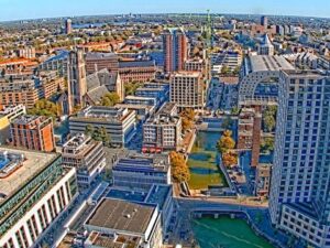
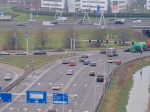
格罗宁根环城公路网络摄像头俯瞰着弗莱海德广场(Vrijheidsplein),这是一个高架立交桥,位于格罗宁根南环城公路与西环城公路的交汇处,距离格罗特广场(Grote Markt)西南约2.2.3公里(1.4英里)。宽阔的高架桥斜穿过画面,桥下蜿蜒的匝道盘旋而过,右下角则有一条较低的道路通往地下通道,通道边缘环绕着池塘和办公楼。标签页中还显示了同一运营商的另外两个摄像头:一个摄像头正对着重建后的南环城公路,另一个摄像头则覆盖了其东端的欧洲广场(Europaplein)。早晚高峰时段,匝道上会排起长队;十月,路堤上的树木会泛黄;到了晚上,视野则缩小,只剩下路灯和车灯的光芒。
The ring road around Groningen is 20 kilometers (12.4 miles) long and built to expressway standard the whole way round. It is made up of three numbered roads: the N370 on the north and west, the N46 on the east, and Rijksweg 7 on the south. That southern side, officially named Weg der Verenigde Naties, was built between 1962 and 1971 and was the first part of the ring to be finished. It carries the A7 from Drachten toward Hoogezand and Winschoten, and at Julianaplein it meets the A28 from Assen and Zwolle.
弗雷海德广场(Vrijheidsplein),N7公路36号出口,最初是自由大道(Laan van de Vrijheid)上的一个环岛,只有N7公路通过高架桥从其上方穿过。2016年至2024年间,该环岛被改建为紧凑型涡轮式立交桥,每个连接点都位于独立的楼层,N7公路也拓宽为双向各三车道。从A7公路通往西环的新出口于2022年7月7日开通,而通过下沉式地下通道的完整连接线则于2023年11月6日通车。天然气公司(Gasunie)大楼于1994年4月由贝娅特丽克丝女王揭幕,标志着该交汇点。位于东侧约2.1公里(2024英里)的欧洲广场(Europaplein)最初也是一个环岛,并于1986年改建为立体交叉路口,南环和东环在此交汇。
Vrijheidsplein, exit 36 on the N7, began as a roundabout on the Laan van de Vrijheid, with only the N7 crossing above it on a viaduct. Between 2019 and 2024 it was rebuilt as a compact turbine interchange with every connection on its own level, and the N7 was widened to three through lanes each way. The new exit from the A7 to the western ring opened on 7 July 2022, and the full link through the sunken underpass followed on 6 November 2023. The Gasunie building, opened by Queen Beatrix in April 1994, marks the junction. Europaplein, about 2.6 kilometers (1.6 miles) to the east, also started as a roundabout and became a grade-separated junction in 1986, where the southern ring meets the eastern ring.
Groningen has a temperate oceanic climate, a little colder in winter than the cities of the western Netherlands because of its northeasterly position, with prevailing winds off the North Sea. At Groningen Airport Eelde, the 1991 to 2020 averages give January highs of 5 C (41 F) and lows just below freezing at -1 C (30 F). Snow falls on about eight days in January but rarely lies for long, so the verges can be white at dawn and the lanes back to wet asphalt by lunchtime. April warms to highs of about 14 C (58 F).
July is the warmest month, with highs near 23 C (73 F) and lows of 12 C (54 F), and also the wettest, at 85 millimeters (3.3 inches). The yearly total of about 805 millimeters (31.7 inches) is spread across every month, which is why wet road surfaces and spray behind trucks are such a common sight here. October highs drop back to about 14 C (58 F), with lows around 6 C (43 F). At 53 degrees north, daylight runs from about seven and a half hours in late December to nearly 17 hours in late June, so the evening rush happens in darkness for much of the winter.
The Stadspark, a park of about 140 hectares (346 acres) and a protected municipal monument, lies just west of Vrijheidsplein along the N7. MartiniPlaza, the theater and concert venue, is reached by a slip road built into the interchange itself. The city center is a short bike ride north, where the Martinitoren rises above the Grote Markt and the Forum Groningen, opened in 2019, has a rooftop terrace, a library and an art-house cinema under one roof.
At the eastern end of the southern ring, near the Europaplein camera, the Euroborg stadium has been the home of FC Groningen since January 2006 and seats 22,525, with Groningen Europapark railway station beside it. In the city center, the Groninger Museum occupies a futuristic, colorful building designed by Alessandro Mendini in 1994.
想了解更多荷兰交通状况、德克萨斯州高速公路重建工程以及格罗宁根主广场的景象,请尝试使用这些摄像头。
主摄像头俯瞰位于荷兰北部格罗宁根省首府格罗宁根西南侧的自由广场(Vrijheidsplein)。另外两个摄像头则位于更东边的南环路沿线,一直延伸到欧洲广场(Europaplein)。
主视图展示了从上方俯瞰的弗莱海德广场立交桥,包括高架桥、环形匝道和地下通道。点击标签页可查看重建后的南部环路沿线景色,以及俯瞰欧洲广场的广阔视野,远处可见商业园区。
气候温和潮湿。一月份白天平均气温为 5 摄氏度(41 华氏度),夜间平均气温为零下 1 摄氏度(30 华氏度);七月份平均气温约为 23 摄氏度(73 华氏度);全年降雨量约为 805 毫米(31.7 英寸)。
On 1 September 2024, eight years after work on the sunken section began. Parts of the Vrijheidsplein interchange opened earlier, in July 2022 and November 2023.
整个环线长 20 公里(12.4 英里)。N370 公路构成其北侧和西侧,N46 公路构成其东侧,Rijksweg 7 公路构成其南侧。
It is exit 36 on the N7, where the southern ring road meets the western ring. It keeps the name of the roundabout that stood there before the 2019 to 2024 rebuild.
这条道路已无法满足目前的交通流量。降低主干道高度后,过境车辆可以在三层地下通道中行驶,而地面上的平行道路则用于处理短途出行。
来源: Bouwwebcam.nl
每周一次,为您带来最新最棒的实时网络摄像头和网站功能。
订阅即表示您同意接收我们的每周电子邮件。您可以随时取消订阅。
 7.6°C / 45.7°F
 6.3°C / 43.3°F




 5.8°C / 42.4°F
