
 Deutsch
 简体中文
 English
 Français
 Español
 Nederlands
 Svenska
 Italiano
 日本語
 Polski
 Português
 Русский
 Ελληνικά
 العربية
 Türkçe
Live
Stream hours: This is a still camera: the operator uploads a new picture every 15 minutes, and the player picks it up automatically, so there is no need to reload the page.
 12:04:54
 -3.2°C / 26.2°F
 Wolkig
 69%
 13 km/h / 8 mph
 08:44
 17:33
Wettervorhersage wird geladen…


East Beach, White Rock Promenade, White Rock, British Columbia, Kanada
 7.5°C / 45.5°F
11:04


Pont Laviolette, Trois-Rivières-Ouest, QC, Kanada
10.9°C / 51.6°F
14:04
Carleton Place, Lanark County, Ontario, Kanada
11.6°C / 52.9°F
14:04



Flugzeuge am Boden und in der Luft im Umkreis von ca. 22 km (14 Meilen) um den Flughafen, Aktualisierung alle 10 Sekunden. Tippen Sie auf ein Flugzeug oder einen Flug in der Liste, um Details anzuzeigen. Die Höhenangaben beziehen sich auf die Höhe über dem Meeresspiegel. Die Positionsdaten stammen von freiwilligen ADS-B-Empfängern, daher werden an manchen Flughäfen nur wenige oder gar keine Flugzeuge am Boden angezeigt.
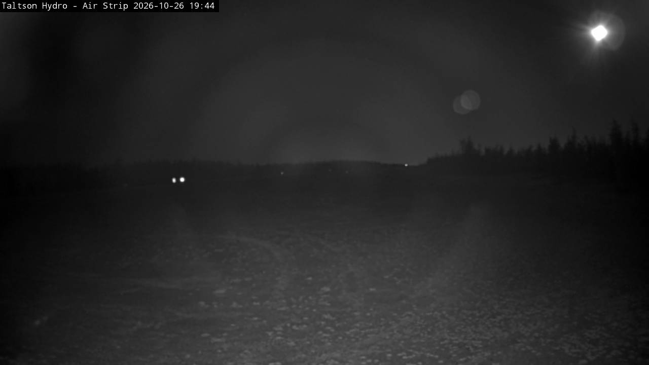
The Taltson Hydro Webcam looks straight down the gravel airstrip that serves the Twin Gorges hydroelectric plant on the Taltson River, in Canada’s Northwest Territories, about 53 kilometers (33 miles) northeast of Fort Smith. The strip runs away from the camera toward a flat, open horizon, with walls of spruce and other conifers on both sides and a wide sky filling the top half of the frame. There is no town out here, so the picture is mostly about light and weather: low autumn sun skimming the gravel, cloud decks rolling in over the forest, and snow settling on the strip in winter. A parked vehicle sometimes noses into the lower right corner, a reminder that this is a working site. The light changes a lot over the year at this latitude, from short midwinter days to June evenings that barely get dark.
The plant stands at Twin Gorges on the Taltson River, a waterway of roughly 750 kilometers (470 miles) that flows north into Great Slave Lake after passing through a chain of lakes that includes Nonacho Lake, Taltson Lake and Tsu Lake. Its basin, between Lake Athabasca and Great Slave Lake, is classed as a subhumid, high boreal ecoclimate, which is exactly what the frame shows: thin conifer forest on flat ground, stretching to the skyline. The dam was built in 1966 to supply power to the lead-zinc mine at Pine Point. Today the station runs an 18 megawatt hydro unit, backed by a 300 kilowatt emergency diesel generator, and its transmission lines carry power to Fort Smith, Hay River, Fort Resolution and Enterprise.
The camera is part of a weather station run by CasCom, a managed technology and communications provider headquartered in Yellowknife that also works in radio systems and satellite links. The station gives its altitude as 258 meters (846 feet) and its position as 60 degrees 23.88 minutes north, 111 degrees 20.88 minutes west, and it shares its readings with Windy and Weather Underground. Current conditions, daily and monthly records and an almanac sit alongside the camera on the station’s own pages.
Taltson is also at the center of a long-running plan to grow hydro power in the territory. The Government of the Northwest Territories’ Taltson Hydro Expansion Project would add 60 megawatts to the existing 18 megawatt facility, with no new flooding, and link it by a new transmission line to the Snare hydro system that serves the Yellowknife area. Two routes are being advanced: about 805 kilometers (500 miles) of line following the highways around Great Slave Lake, or about 320 kilometers (199 miles) from Twin Gorges to Yellowknife, half overhead and half as a submarine cable. The government estimates the expansion could cut up to 240,000 tonnes of greenhouse gas emissions a year, and the Government of Canada has committed $20 million to the work since 2018.
There is no long climate record at the plant itself, so Fort Smith, at 205 meters (673 feet), is the nearest guide. Winters are long and severe. January averages a high of minus 17.4 C (0.7 F) and a low of minus 26.2 C (minus 15.2 F), and Fort Smith’s record low is minus 57.2 C (minus 71 F), set in December 1917. About 142 centimeters (56 inches) of snow falls in an average year, so through the cold months the camera typically shows a pale strip between dark trees under a low sun. Around the December solstice the sun is up for less than 6 hours a day at this latitude.
Summer swings the other way. July highs average 23.6 C (74.5 F) with lows near 11.1 C (52 F), and Fort Smith reached 39.9 C (103.8 F) on June 30, 2021. Near the June solstice the sun stays up for close to 19 hours, so the camera keeps showing daylight late into the evening. It is a dry climate, with about 360 millimeters (14.2 inches) of precipitation a year, which is why clear skies and long views to the horizon are common. Spring and autumn are short: in mid-October the station’s own almanac puts sunrise just after 8 am and sunset just after 6 pm local time.
Fort Smith is the nearest town and the practical base for the area, with 2,248 residents at the 2021 census. Its riverfront looks over the Slave River rapids, a run of white water that includes Cassette Rapids, Pelican Rapids, Mountain Rapids and the Rapids of the Drowned. Riverbank Park has groomed trails and a viewing platform above the rapids, and Fort Smith Mission Park keeps historic mission buildings and a Catholic grotto.
The Northern Life Museum covers the town’s past, and the town also keeps the museum ship Radium King. Fort Smith is also home to the headquarters of Wood Buffalo National Park. Farther afield, the Taltson River ends in Great Slave Lake, and Yellowknife, the territorial capital, lies about 279 kilometers (173 miles) north-northwest of the plant in a straight line.
For more northern skies and remote airfields, try these cameras.
Taltson Hydro is at Twin Gorges on the Taltson River in the Northwest Territories, Canada, about 53 kilometers (33 miles) northeast of Fort Smith and roughly 279 kilometers (173 miles) from Yellowknife. The river drains north into Great Slave Lake.
The gravel airstrip at the plant, seen end-on, with conifer forest along both sides, a flat horizon and a large sky. A parked vehicle sometimes appears in the lower right corner.
Cold and dry for most of the year. Nearby Fort Smith averages minus 17.4 C (0.7 F) by day in January and 23.6 C (74.5 F) in July, with about 142 centimeters (56 inches) of snow a year.
In 1966, to supply power to the lead-zinc mine at Pine Point, and the plant has kept generating for the region ever since.
Fort Smith, Hay River, Fort Resolution and Enterprise, through transmission lines from the 18 megawatt station.
A territorial government plan to add 60 megawatts at Taltson and connect it to the Snare hydro system near Yellowknife, either by a line around Great Slave Lake or by a shorter route with a submarine cable.
At about 60 degrees north, the sun is up for close to 19 hours around the June solstice and for less than 6 hours around the December solstice.
Source: CasCom
Die besten neuen Live-Webcams und Website-Funktionen, einmal pro Woche.
Mit Ihrer Anmeldung erklären Sie sich damit einverstanden, unseren wöchentlichen Newsletter zu erhalten. Sie können sich jederzeit abmelden.
 11.7°C / 53.1°F