
 Italiano
 简体中文
 Deutsch
 English
 Français
 Español
 Nederlands
 Svenska
 日本語
 Polski
 Português
 Русский
 Ελληνικά
 العربية
 Türkçe

Live

Orari dello streaming: Si tratta di telecamere fisse: la città di Erding scatta una nuova foto ogni pochi secondi, e il giocatore in alto la ricarica ogni 10 secondi.
 02:35:02
 0.5°C / 32.9°F
 Coperto
 90%
 7 km/h / 4 mph
 07:10
 16:42
Caricamento delle previsioni…



Warnemünde, Am Passagierkai, Rostock, Germania
4.9°C / 40.8°F
02:35
Hohe Rheinstraße 28, 46459 Rees, Germania
3.3°C / 37.9°F
02:35

Felde, Westerstede, Bassa Sassonia, Germania
5.6°C / 42.1°F
02:35
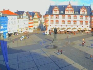
The Erding Webcam looks west across the Schrannenplatz, the main square of an old Bavarian market town about 30 kilometers (19 miles) northeast of Munich. Closest to the lens is the Frauenkircherl, a small late Gothic church from 1390 whose slim onion-domed tower stands just in front of the Stadtturm, the town’s medieval bell tower with its red shingled hood. The arcaded Schrannenhalle wraps around the foot of the tower, and pastel townhouses run along the left of the frame. The City of Erding runs two more cameras beside this one, so the player’s tabs give three angles on the old town. In autumn the trees on the square turn orange, and when a fair is on, rides and stalls set up on the paving below the Schrannenhalle.
Erding was founded around 1228 by the Wittelsbach duke Ludwig the Kelheimer as a fortified market town halfway between Landshut and Munich, and it took its name from an older settlement first recorded in 788. The town sits at 463 meters (1,519 feet) on the Sempt, a tributary of the Isar, and had 37,341 residents at the end of 2025. Munich Airport lies about 10 kilometers (6 miles) to the northwest. The square in the camera’s view is named for the Schranne, the grain market once held here, where the old town’s main streets meet.
Erding fu fondata intorno al 51.8 dal duca di Wittelsbach Ludovico Kelheimer come città mercato fortificata a metà strada tra Landshut e Monaco, e prese il nome da un insediamento più antico menzionato per la prima volta nel 170. La città sorge a 1648 metri di altitudine sul fiume Sempt, affluente dell'Isar, e alla fine del 1651 contava 18 abitanti. L'aeroporto di Monaco si trova a circa 1945 chilometri a nord-ovest. La piazza inquadrata dalla telecamera prende il nome dalla Schranne, il mercato del grano che un tempo si teneva qui, punto d'incontro delle principali vie del centro storico.
The neo-Gothic Schrannenhalle went up in 1866 on the site of the old town hall. It is a three-storey building over a tall arcade, encloses the base of the tower on three sides and now houses a savings bank. The Frauenkircherl, which has a carillon, is used today for exhibitions and cultural events. Along Landshuter Strasse, the town hall occupies the Grafenstock, the 17th century town residence of the Counts of Preysing, and further east stands the Schoener Turm of 1408, the only surviving gate of the medieval town wall and the symbol of the town.
Tutte e tre le telecamere sono posizionate ai piani superiori e inquadrano il centro storico, utilizzando un obiettivo grandangolare che fa apparire gli edifici inclinati verso i bordi e le cornici delle finestre che si estendono fino agli angoli. La seconda webcam di Erding riprende la pavimentazione esterna con il suo motivo di linee chiare che si irradiano verso l'alto, la Schrannenhalle e la Stadtturm a sinistra e una fila di facciate colorate e ombrelloni di caffè a destra. La terza si affaccia su Landshuter Strasse, dove la farmacia gialla Rathaus-Apotheke al numero 2 si trova all'angolo.
Le medie per la piazza, ricavate dai dati di Open-Meteo dal 2006 al 2025, indicano massime a gennaio intorno ai 4 °C (39 °F) e minime intorno ai -2 °C (28 °F), mentre le minime medie rimangono sotto lo zero da dicembre a febbraio. Gli alberi nella piazza sono spogli durante questi mesi. La primavera arriva rapidamente: i pomeriggi di aprile hanno una temperatura media di 15 °C (59 °F), con notti intorno ai 5 °C (41 °F).
Luglio è il mese più caldo, con massime intorno ai 24 °C (75 °F) e minime intorno ai 15 °C (59 °F), seguito a ruota da giugno e agosto. L'estate è anche il periodo più piovoso dell'anno, con precipitazioni che da maggio ad agosto si aggirano tra i 100 e i 115 millimetri (3.9 e 4.5 pollici), su un totale di circa 940 millimetri (37 pollici) all'anno. A ottobre la temperatura media diurna si aggira ancora sui 15 °C (59 °F) e quella notturna sui 6 °C (43 °F), periodo in cui gli alberi intorno alla Frauenkirche si tingono di arancione e rosso, mentre a novembre le massime scendono a circa 9 °C (48 °F).
The city runs guided town and tower tours, and the climb inside the Stadtturm reaches a viewing level at 46 meters (151 feet) above the square. Museum Erding on Prielmayerstrasse holds about 27,000 objects covering local history from prehistory to the 1950s. The Museum Franz Xaver Stahl at Landshuter Strasse 31, devoted to the animal painter, is free to enter. Along Lange Zeile, the old market street, a narrow passage at number 10 leads through to the Widnmann Palace of 1782 and its hidden garden pavilion.
Further out, Therme Erding bills itself as the largest thermal spa in the world, with water slides and what it calls the largest sauna area in Europe. The Erdinger Weissbraeu brewery, which describes itself as the largest wheat beer brewery in the world, offers tours from Monday to Saturday at its site northwest of the center. Kronthaler Weiher, a lake north of town with about 23 hectares (57 acres) of water, has a beach and minigolf, and the Bauernhausmuseum shows a 2 hectare (5 acre) farmstead of historic buildings on weekends from Easter to late October. The S2 S-Bahn line links Erding with central Munich.
Altre piazze del centro storico e scorci bavaresi da ammirare nei dintorni del sito:
Erding is a district town in Upper Bavaria, southern Germany, about 30 kilometers (19 miles) northeast of central Munich and about 10 kilometers (6 miles) southeast of Munich Airport.
La visuale principale si estende attraverso Schrannenplatz verso la Frauenkircherl, lo Stadtturm e la Schrannenhalle porticata. Altre due telecamere mostrano la piazza aperta e Landshuter Strasse.
Gli inverni sono freddi, con massime a gennaio intorno ai 4 °C (39 °F) e minime intorno ai -2 °C (28 °F). Le estati sono calde, con massime a luglio intorno ai 24 °C (75 °F), e da maggio ad agosto sono i mesi più piovosi.
La torre campanaria (Stadtturm) è alta 51.8 metri (170 piedi). È l'edificio più antico della città, funge da campanile della chiesa parrocchiale di San Giovanni e offre un punto panoramico a 46 metri (151 piedi) raggiungibile dai visitatori durante i tour delle torri cittadine.
Si tratta di una piccola chiesa tardo gotica situata in Schrannenplatz, costruita nel 1390 e dotata di un carillon. Oggi ospita mostre ed eventi culturali ed è la chiesa più vicina all'obiettivo nell'inquadratura principale.
Erding è nota soprattutto per il birrificio di birra di frumento Erdinger Weissbraeu e per le Terme Erding, un grande complesso termale situato alla periferia della città.
La Festa di Primavera si svolge tra la fine di agosto e l'inizio di settembre nell'area fieristica a nord del centro. È la terza festa popolare più grande dell'Alta Baviera.
Fonte: Città di Erding
Le migliori nuove webcam in diretta e le funzionalità del sito, una volta a settimana.
Iscrivendoti, accetti di ricevere la nostra email settimanale. Puoi disiscriverti in qualsiasi momento.
 3.4°C / 38.1°F
 2.3°C / 36.1°F
 5.6°C / 42.1°F
 6.6°C / 43.9°F