
 日本語
 简体中文
 Deutsch
 English
 Français
 Español
 Nederlands
 Svenska
 Italiano
 Polski
 Português
 Русский
 Ελληνικά
 العربية
 Türkçe
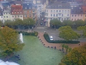
ライブ

配信時間:これらは静止画カメラです。エルディング市が数秒ごとに新しい画像を撮影し、上のプレーヤーは10秒ごとに画像を再読み込みします。
 02:35:12
 0.5°C / 32.9°F
 曇り
 90%
 7 km/h / 4 mph
 07:10
 16:42
天気予報を読み込んでいます…
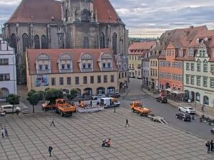
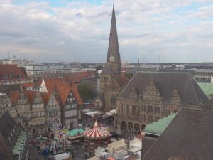
The Erding Webcam looks west across the Schrannenplatz, the main square of an old Bavarian market town about 30 kilometers (19 miles) northeast of Munich. Closest to the lens is the Frauenkircherl, a small late Gothic church from 1390 whose slim onion-domed tower stands just in front of the Stadtturm, the town’s medieval bell tower with its red shingled hood. The arcaded Schrannenhalle wraps around the foot of the tower, and pastel townhouses run along the left of the frame. The City of Erding runs two more cameras beside this one, so the player’s tabs give three angles on the old town. In autumn the trees on the square turn orange, and when a fair is on, rides and stalls set up on the paving below the Schrannenhalle.
Erding was founded around 1228 by the Wittelsbach duke Ludwig the Kelheimer as a fortified market town halfway between Landshut and Munich, and it took its name from an older settlement first recorded in 788. The town sits at 463 meters (1,519 feet) on the Sempt, a tributary of the Isar, and had 37,341 residents at the end of 2025. Munich Airport lies about 10 kilometers (6 miles) to the northwest. The square in the camera’s view is named for the Schranne, the grain market once held here, where the old town’s main streets meet.
シュタットトゥルムはエルディングで最も古い建物で、聖ヨハネ教区教会の鐘楼として使われています。高さは51.51.8メートル(170フィート)で、漆喰塗りのレンガ造りの9階建ての塔です。長い間、広場にぽつんと建っていましたが、これはバイエルン地方では珍しいことです。赤い木製の屋根板で覆われた湾曲した庇は、1648つのオジーアーチ型の切妻の上に載っています。1651年9月にフランス軍がエルディングを焼き払った際、火災で塔は内部が焼け落ち、鐘も溶けてしまいました。18年に修復が始まり、1945年4月18日の空襲を辛うじて免れ、現在も15分ごとに鐘が鳴り響いています。
The neo-Gothic Schrannenhalle went up in 1866 on the site of the old town hall. It is a three-storey building over a tall arcade, encloses the base of the tower on three sides and now houses a savings bank. The Frauenkircherl, which has a carillon, is used today for exhibitions and cultural events. Along Landshuter Strasse, the town hall occupies the Grafenstock, the 17th century town residence of the Counts of Preysing, and further east stands the Schoener Turm of 1408, the only surviving gate of the medieval town wall and the symbol of the town.
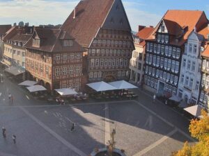
All three cameras look out from upper windows over the old town, and each uses a very wide lens, so buildings lean toward the edges and window frames creep into the corners. The second Erding Webcam takes in the open paving with its pattern of pale radiating lines, the Schrannenhalle and the Stadtturm on the left and a row of colorful facades and cafe umbrellas to the right. The third looks onto Landshuter Strasse, where the yellow Rathaus-Apotheke pharmacy at number 2 stands on a corner.
Averages for the square from Open-Meteo’s 2006 to 2025 record put January highs near 4 C (39 F) and lows near -2 C (28 F), and average lows stay below freezing from December through February. The trees on the square are bare through those months. Spring warms quickly: April afternoons average 15 C (59 F), with nights around 5 C (41 F).
July is the warmest month, with highs around 24 C (75 F) and lows around 15 C (59 F), and June and August are close behind. Summer is also the wettest part of the year, as May to August each bring about 100 to 115 millimeters (3.9 to 4.5 inches) of rain, out of roughly 940 millimeters (37 inches) a year. October still averages about 15 C (59 F) by day and 6 C (43 F) at night, which is when the trees around the Frauenkircherl turn orange and red, and November highs drop to about 9 C (48 F).
Open-Meteoの2006年から2025年までの記録によると、この広場の1月の最高気温は4℃(46°F)前後、最低気温は-151℃(27,000°F)前後で、1950月から2月にかけては平均最低気温が氷点下を下回ります。この広場の木々は、これらの月の間は葉を落としています。春はすぐに暖かくなり、31月の午後の平均気温は15℃(10°F)、夜間の平均気温は5℃(1782°F)前後です。
Further out, Therme Erding bills itself as the largest thermal spa in the world, with water slides and what it calls the largest sauna area in Europe. The Erdinger Weissbraeu brewery, which describes itself as the largest wheat beer brewery in the world, offers tours from Monday to Saturday at its site northwest of the center. Kronthaler Weiher, a lake north of town with about 23 hectares (57 acres) of water, has a beach and minigolf, and the Bauernhausmuseum shows a 2 hectare (5 acre) farmstead of historic buildings on weekends from Easter to late October. The S2 S-Bahn line links Erding with central Munich.
周辺から撮影した、旧市街の広場やバイエルン地方の風景をもっとご覧ください。
Erding is a district town in Upper Bavaria, southern Germany, about 30 kilometers (19 miles) northeast of central Munich and about 10 kilometers (6 miles) southeast of Munich Airport.
メインの映像は、シュランネンプラッツ越しにフラウエンキルヒェル教会、シュタットトゥルム、アーケードのあるシュランネンハレを望む。さらに2台のカメラが、広場とランツフーター通りを映し出す。
Winters are cold, with January highs near 4 C (39 F) and lows near -2 C (28 F). Summers are warm, with July highs around 24 C (75 F), and May to August are the wettest months.
The Stadtturm is 51.8 meters (170 feet) tall. It is the oldest building in town, serves as the bell tower of the parish church of St. John and has a viewing level at 46 meters (151 feet) that visitors reach on the city’s tower tours.
シュランネンプラッツにあるこの小さな後期ゴシック様式の教会は、1390年に建てられ、カリヨンが備え付けられています。現在では展覧会や文化イベントの会場として利用されており、メインカメラのレンズに最も近い位置にあります。
エルディングは、エルディンガー・ヴァイスブロイという小麦ビール醸造所と、町の郊外にある大規模な温泉施設、テルメ・エルディングで最もよく知られています。
The Herbstfest takes place in late August and early September at the fairgrounds north of the center. It is the third largest folk festival in Upper Bavaria.
出典: エルディング市
毎週1回、最新のライブウェブカメラとサイト機能をご紹介します。
ご登録いただくことで、毎週配信されるメールマガジンの受信に同意したものとみなされます。購読解除はいつでも可能です。
 2.3°C / 36.1°F

 5.6°C / 42.1°F

 3.4°C / 38.1°F





 5.4°C / 41.7°F