Live

 23:53:47
 6.7°C / 44.1°F
 Overcast Clouds
 93%
93% 7 km/h / 4 mph
 08:28
08:28 18:21
18:21Loading forecast…
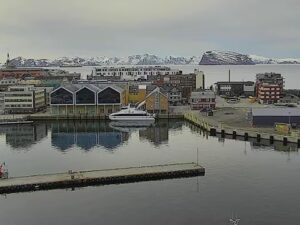
The Maloy Webcam looks west across the Ulvesundet strait at Maloy, the fishing town on the island of Vagsoy in Vestland, Norway. The camera stands on the mainland shore of the strait, and it is a pan-tilt-zoom unit that cycles through several presets. Tight on the Maloy Bridge, the long concrete arch that carries the road onto the island fills the left of the frame. On the fishing quays, purse seiners and trawlers lie two abreast below a white wooden church. On the widest preset the whole town climbs the hillside in white and red houses, with two bare peaks behind it, and another preset turns north along the strait to where it opens into the sea. Fishing boats and work boats cross the water all day.
Maloy is a town of 3,343 people (2024) packed onto 2.22 square kilometers (0.86 square miles) of the eastern shore of Vagsoy, an island of 59.1 square kilometers (22.8 square miles) on the coast of Nordfjord. The town started as a trading post on Moldoen, the small island in the strait that is still called Maloya, and moved across to the larger island as trade grew while keeping the smaller island’s name. It was the administrative center of Vagsoy Municipality from 1964 until the 2020 merger that created Kinn Municipality. Most streets on the hillside are numbered rather than named.
The strait that fills the bottom half of the frame is Ulvesundet, the sheltered channel between Vagsoy and the mainland that made Maloy one of the most important fishing ports in Norway. The Maloy Bridge crosses its narrow southern end, Maloystraumen, between the town and Deknepollen on the mainland. It is 1,224 meters (4,016 feet) long with a main span of 125 meters (410 feet) and 42 meters (138 feet) of clearance for shipping, and it opened to traffic in December 1973 before its official inauguration on 11 July 1974.
The small island in the strait was turned into a German coastal fortress during the Second World War, and every house on it was cleared to make room. On 27 December 1941 British commandos landed on Vagsoy in Operation Archery, the raid that gave the town its place in wartime history. Martin Linge was the only Norwegian killed, and the town keeps a memorial to him along with a war monument on the town square.
Maloy has an oceanic climate with mild, wet, windy winters and cool summers. The January mean is 4.0 C (39 F), and over the last ten years January days have typically peaked around 4 C (39 F) and dipped to about 0 C (32 F) at night, so snow on the quays is rare and short-lived, though the peaks above the town often carry a white cap in winter. Spring comes slowly, with April highs near 8 C (46 F).
August is the warmest month with a mean of 14.2 C (58 F), and July and August afternoons typically reach about 16 C (61 F). The sea delays the seasons, so September is often as warm as June. Rain is the constant: the town records about 1,833 millimeters (72 inches) a year, with September and October the wettest months, and autumn gales funnel down the strait, which is when the whitecaps show. Kraakenes lighthouse at the northern tip of the island holds Norway’s record for the strongest wind ever measured, and Maloy is only slightly sheltered from the same weather. In December the camera’s useful daylight shrinks to a few hours around midday, while in late June it is light almost around the clock.
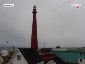
Most visitors drive out to the north end of the island. Kraakenes lighthouse, built in 1906 on a plateau 45 meters (148 feet) above the sea with water on three sides, is about 18 kilometers (11 miles) by road from the town center along National Road 618, and it has its own weather station that reports to the Norwegian Meteorological Institute. On the way is Refvik, whose sandy beach, Refviksanden, faces the open ocean. Kannesteinen, the sea-carved rock on the shore of Vagsoy, is the island’s most photographed landmark, and two more lighthouses, Hendanes and Skongenes, stand on the coast.
The island’s highest point, Veten, rises 613 meters (2,011 feet) above sea level and looks down on the whole strait, the bridge and the fishing fleet. Back in town, Sor-Vagsoy Church is the white wooden church on the camera’s quayside preset, and the annual Maloydagene festival fills the town square in summer. A car ferry runs from Maloy to Oldeide on Bremangerlandet to the south, calling at Husevagoy on some departures.
More live views from the same coast.
The camera cycles between presets. One is tight on the Maloy Bridge, one shows the fishing quays and the white church at the south end of town, one takes in the whole town center with the two peaks behind it, and one looks north along the Ulvesundet strait to its mouth. Boats on the strait are in frame on every preset.
Yes. The town’s waterfront quays run across the middle of the wide preset, and the fishing-boat preset zooms in on vessels moored two abreast. A larger ship berthed along the town side of the strait is visible when the camera is on the town view. There is no dedicated cruise-quay preset.
Maloy is on the island of Vagsoy in Kinn Municipality, Vestland county, on the west coast of Norway at the mouth of Nordfjord. It is on the Ulvesundet strait between the island and the mainland, and the nearest airport is Alesund to the northeast.
Mild, wet and windy. January averages 4.0 C (39 F) and August 14.2 C (58 F), with about 1,833 millimeters (72 inches) of rain a year and the heaviest falls in September and October. Snow in town is rare, but the peaks behind it are often white in winter.
Maloy had 3,343 residents in 2024, on 2.22 square kilometers (0.86 square miles). The whole island of Vagsoy had 4,207 residents at the 2001 count.
Yes, on one of the presets. The 1,224 meter (4,016 foot) bridge crosses the southern end of the strait to the left of the camera, and when the camera turns that way the arch and its approach spans fill the frame.
Drive to Kraakenes lighthouse at the island’s northern tip, walk Refviksanden beach, photograph the Kannesteinen rock, climb Veten for the view over the strait, and visit the Martin Linge memorial in town.
The stream is part of the Live Norway network of coastal cameras on YouTube, run by Triangel Security, whose logo sits in the corner of the picture. The same network streams Nordfjordeid and Kraakenes lighthouse nearby.
Source: Live Norway
The best new live webcams and site features, once a week.
By subscribing you agree to receive our weekly email. Unsubscribe any time.
 1.6°C / 34.9°F
 -1°C / 30.2°F

 1.5°C / 34.7°F




 4°C / 39.2°F
 1°C / 33.8°F