 English
 简体中文
 Deutsch
 Français
 Español
 Nederlands
 Svenska
 Italiano
 日本語
 Polski
 Português
 Русский
 Ελληνικά
 العربية
 Türkçe

Live
Heraklion, Greece
Morosini Lions Fountain, Platia Eleftheriou Venizelou, Heraklion, Greece
 17.4°C / 63.3°F
 06:1106:11:30
 19.7°C / 67.5°F
 Light Rain
 72%
 31 km/h / 19 mph
 07:05
 17:12
Loading forecast…
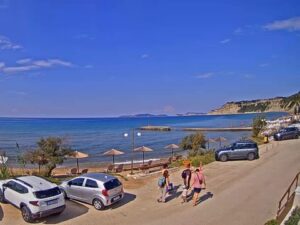
The Patitiri Webcam looks out from the paved quay at the main port of Alonissos, a Greek island in the Northern Sporades. A wide brick apron fills the foreground, with cars parked along its right edge, and past it the harbor opens toward the Aegean. Tree-topped cliffs run down the right side above a concrete jetty. On the left, moored boats line the shore below a wooded hillside, and a long stone breakwater reaches out behind them. A second camera on the next tab looks over the same port from higher up, across a large car park to the breakwater and the headland. What changes from one visit to the next is the boats at their moorings, the vessels at the quay and the light on the water.
Patitiri is the main port of Alonissos, on the southeast of the island. It has not always been the island’s center. Until 1965 it served as the seaport for the old capital at Chora, up the hill. An earthquake on 9 March 1965 heavily damaged the village, and many of its people settled at the port rather than go back. Votsi and Roussoum Gialos, two nearby settlements, grew up after the same disaster, and rebuilding was quick enough that Roussoum Gialos has since grown together with Patitiri.
The port owes its role to its shape. It is a natural harbor, and sailing guides note its shelter from the northerly winds that prevail here in summer. You can read that shelter in the frame: the cliffs and the breakwater close in the water, leaving a gap of open sea between them. Alonissos itself covers 64 square kilometers (25 square miles) and rises to 476 meters (1,562 feet). The 2021 census counted 3,138 residents across the municipality, 33 of them on its other islands.
Patitiri is also the main gateway to the National Marine Park of Alonissos and the Northern Sporades, created in 1992 to protect the endangered Mediterranean monk seal. The park covers more than 2,200 square kilometers (850 square miles) of sea and islands, and day boats to its zones leave from this port.
The sea keeps temperatures moderate. Reanalysis data for 2011 to 2020 gives average highs of about 11°C (52°F) in January, 17°C (63°F) in April, 27°C (81°F) in July and August, and 20°C (68°F) in October. Those figures come from a grid cell that is mostly open water, so a sheltered quay can run warmer on a still summer afternoon.
Winter is the wet season, with roughly 100 millimeters (3.9 inches) of rain a month in December and January against about 20 millimeters (0.8 inches) in July. On the camera, that can mean gray skies and wet brick on the quay in the cooler months. Summer is far drier, so the paving usually stays dry and the view out past the breakwater is more often clear.
Chora, the old village signposted as The Old Village, sits about 4 kilometers (2.5 miles) from the harbor, and local buses start from Patitiri. It was largely abandoned after the 1965 earthquake, the same event that made the port the island’s center. Back in Patitiri, a privately run folklore museum covers the island’s pirate history and traditional crafts, and the town has cafes, restaurants and shops.
Tours into the marine park often stop at Kyra Panagia, an uninhabited island about 7 kilometers (4.3 miles) off the northern tip of Alonissos, where passengers can climb to its monastery. For a swim closer to town, Roussoum Gialos has sunbeds and a basic beach bar. The island’s beaches are pebble rather than sand. Ferries, catamarans and hydrofoils have linked Patitiri with Skopelos, Skiathos, Skyros and the mainland at Volos and Agios Konstantinos, so check current timetables before planning a hop.
These cams cover another Aegean island, a working harbor elsewhere in Europe, and a very different side of Greece.
The main camera shows the brick quay, parked cars, the harbor water, a concrete jetty under the cliffs on the right, and moored boats and the breakwater on the left. The second tab looks over the same port from higher up, with red-roofed buildings and a car park in the foreground.
Patitiri is on the southeast of Alonissos, in the Northern Sporades of Greece. It is the island’s main port, about 4 kilometers (2.5 miles) from the old village of Chora.
Yes. Patitiri is the main port of Alonissos, and both views come from the Municipality of Alonissos, which runs them on its own YouTube channel.
No. The old town is Chora, about 4 kilometers (2.5 miles) from the harbor, and neither view we checked includes it. Both cameras look toward the sea.
No. Neither view we checked includes a swimming beach. They show the quay, the car park, the breakwater and the rocky shore of the harbor.
Sometimes. A yellow passenger vessel was moored in both views when we checked, near the breakwater on the main camera and at the quay on the right of the second tab. What is in port depends on the season and the timetable.
Mild and wet in winter, warm and dry in summer. Average highs run from about 11°C (52°F) in January to about 27°C (81°F) in July and August, and most of the rain falls between November and March.
Take a boat trip into the National Marine Park, visit the old village of Chora, see the folklore museum in Patitiri, or swim at Roussoum Gialos.
Source: Municipality of Alonissos
The best new live webcams and site features, once a week.
By subscribing you agree to receive our weekly email. Unsubscribe any time.

 18.8°C / 65.8°F


 17.6°C / 63.7°F



 16.2°C / 61.2°F


 1.3°C / 34.3°F
 10°C / 50°F