 English
 简体中文
 Deutsch
 Français
 Español
 Nederlands
 Svenska
 Italiano
 日本語
 Polski
 Português
 Русский
 Ελληνικά
 العربية
 Türkçe
Live
 13:23:16
 8.9°C / 48°F
 Overcast Clouds
 97%
 7 km/h / 4 mph
 07:36
 16:29
Loading forecast…
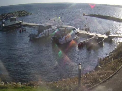
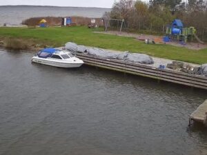
The Koljunuki Harbor Webcam looks over a small marina on Ihasalu Bay at Ulgase, a coastal village about 20 kilometers (12 miles) east of Tallinn in northern Estonia. A floating pier runs across the middle of the frame with motorboats tied along it, two arms of piled stone close off the basin on either side, and beyond them the open bay reaches out to a low line of shore on the horizon. A grassy bank, a footpath and a small bollard light fill the foreground. The scene follows the Baltic year, from the summer boating season to midwinter days when the noon sun climbs only about 7 degrees. Around midday in autumn the camera looks toward the sun, which can lay a bright path of glare across the water on the right.
Koljunuki Harbor sits on the shore of Ihasalu Bay in Ulgase village, part of Joelahtme Parish in Harju County, with the Ihasalu peninsula about 4.5 kilometers (2.8 miles) to the east and northeast. It is a small, practical harbor. The floating pier has 22 berths, 10 of them kept for visiting boats, and takes craft up to 10 meters (33 feet) long and 4 meters (13 feet) wide with a draft of up to 2.5 meters (8.2 feet). A 32 meter (105 foot) slipway runs into the water at a slope of 1 in 7 and reaches a depth of 2 meters (6.6 feet), and short launches there are allowed in daylight only.
Koljunuki Sadam, the company that runs the harbor, also has a resort hall with a Finnish sauna and steam bath for up to 20 people, a conference room and four guest rooms, next to Restaurant Veer. A boathouse with repair space and a 500 kilogram (1,100 pound) hoist is open all year and stores boats through the off season by arrangement. The harbor rules ban jet skis, fishing, swimming, drone flights and feeding the waterfowl inside the port area, so the water in front of the camera is left to the boats.
The land behind the harbor has an industrial past. About 2 kilometers (1.3 miles) to the south, the limestone cliff at Ulgase holds the galleries of the Ulgase phosphorite mine, where some of Estonia’s first phosphorite was dug between 1923 and 1938. The cliff and its oak forest have been protected since 1960 as the 50 hectare (120 acre) Ulgase Nature Reserve, and bats now spend the winter in the old mine tunnels. Joelahtme Parish covers 210.86 square kilometers (81.41 square miles) and had 8,007 residents at the start of 2026.
The coast east of Tallinn has a cool Baltic climate. The 1991 to 2020 normals for Tallinn put July, the warmest month, at an average high of 22.2 C (72 F) and a low of 13.1 C (55.6 F). That is the middle of the navigation season, and the long northern days keep the Koljunuki Harbor Webcam in daylight well into the evening, with about 294 hours of sunshine in June. Spring and autumn are cool. April and October both average highs of 9.5 C (49 F), with April nights close to freezing at 0.7 C (33 F) and October nights around 3.7 C (39 F).
Winter is dark and cold. February is the coldest month on average, with highs of minus 1.0 C (30.2 F) and lows of minus 6.2 C (20.8 F), and January is barely milder at minus 0.7 C (30.7 F) by day. December brings only about 21 hours of sunshine in the whole month. The harbor’s navigation season officially ends on 15 October, although some boats were still tied up at the pier a week later in 2026.
The Ulgase Nature Reserve is the nearest walk, about 2 kilometers (1.3 miles) south, where the old phosphorite galleries open into the limestone cliff beneath the oaks. Farther inland, the Rebala Heritage Reserve covers around 70 square kilometers (27 square miles) of farmland and villages with more than 300 archaeological remains, most of them prehistoric stone cist graves and cup marked stones. The Bronze Age stone cist graves at Joelahtme, about 7.5 kilometers (4.7 miles) south of the harbor, and the Kostivere karst area are listed by Visit Harju among the parish’s most noteworthy sights.
Jagala Falls, about 8 kilometers (5 miles) to the southeast, is the largest natural waterfall in Estonia, around 8 meters (26 feet) high and 50 meters (160 feet) wide on the Jagala River, and its cascade freezes over in winter. Along the coast, Kaberneeme harbor, about 11 kilometers (6.6 miles) to the east, is the starting point for boat trips to the Malusi islands to watch seals, and the golf course at Joelahtme is about 5 kilometers (3.1 miles) from the harbor.
More cams from Estonia and from across the Gulf of Finland:
The Koljunuki Harbor Webcam looks over a marina in Ulgase village, Joelahtme Parish, Harju County, on the shore of Ihasalu Bay in northern Estonia. The harbor lies about 20 kilometers (12 miles) east of Tallinn, and boats reach it from Ihasalu Bay.
The camera shows the harbor basin: the floating pier with its moored motorboats, the two stone breakwaters, and Ihasalu Bay beyond them out to the horizon. A grassy bank and a footpath fill the foreground, and a date and time stamp sits in the top left corner of the picture.
Summers are mild, with July highs averaging 22.2 C (72 F) in nearby Tallinn, while winters are cold, with February highs of minus 1.0 C (30.2 F) and lows of minus 6.2 C (20.8 F). Spring and autumn are cool, with average highs of 9.5 C (49 F) in both April and October.
The harbor’s navigation season runs from 15 April to 15 October. The boathouse stays open all year for repairs, and boats can be stored there outside the season by arrangement with the harbor.
Yes, when there is space. Ten of the 22 berths on the floating pier are set aside for visiting boats up to 10 meters (33 feet) long and 4 meters (13 feet) wide, with a draft of up to 2.5 meters (8.2 feet). The harbor gives its position as 59 degrees 30 minutes 18 seconds north, 25 degrees 5 minutes 28.5 seconds east.
The harbor gives the distance as 20 kilometers (12 miles). In a straight line, Town Hall Square in Tallinn’s Old Town is roughly 21 kilometers (13 miles) to the west.
Source: Koljunuki Sadam
The best new live webcams and site features, once a week.
By subscribing you agree to receive our weekly email. Unsubscribe any time.
 10°C / 50°F




 14.9°C / 58.8°F


 10.7°C / 51.3°F