Live

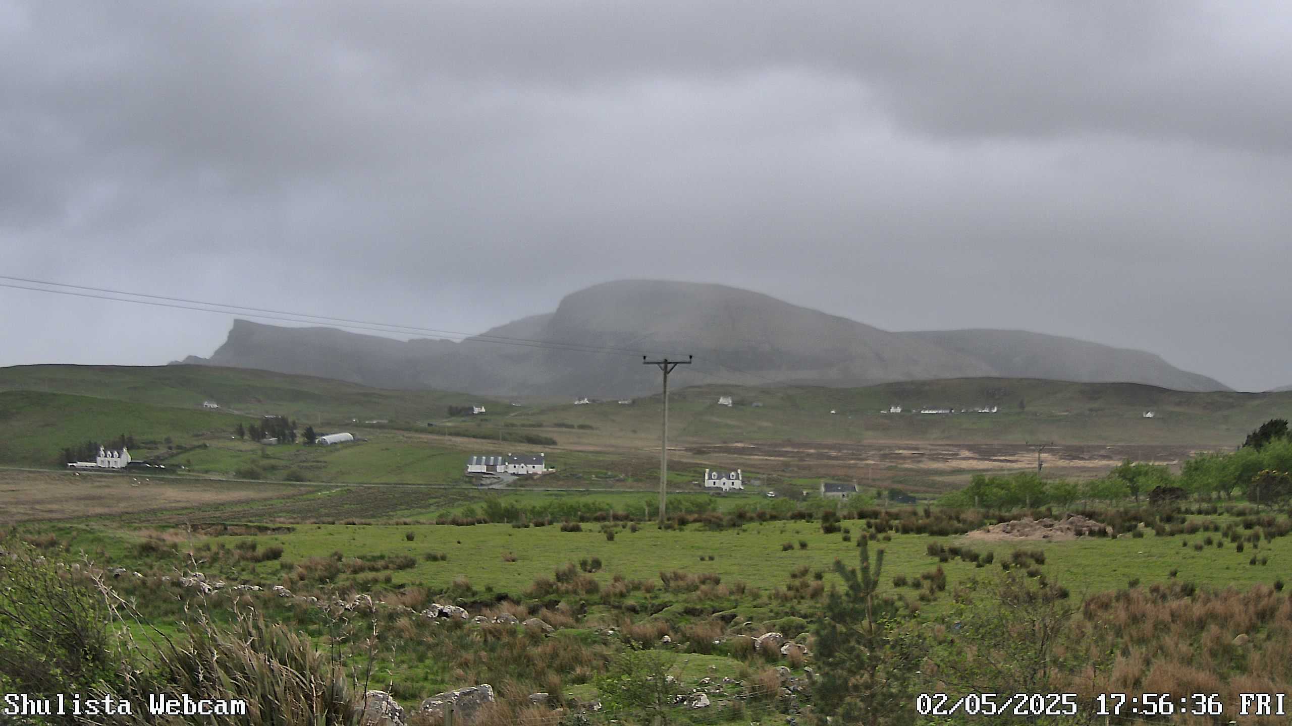
Stream hours: This is a still camera, not a video stream: the weather station replaces the picture with a fresh one every minute, and the player reloads it on its own.
 22:31:39
 8°C / 46.4°F
 Scattered Clouds
 81%
81% 30 km/h / 19 mph
 07:59
07:59 18:22
18:22Loading forecast…
The Isle of Skye Webcam looks south-southeast from the Shulista weather station in Trotternish, the island’s northernmost peninsula, across open croft land to the broad, dark shoulder of Sgurr Mor. Rough grass and rushes fill the foreground, cattle sometimes graze the small fields beyond, and scattered white houses sit along the foot of the hill. The sky takes up nearly half the frame, and on this exposed corner of Skye it is the part worth watching: banks of cloud, bright sunshine and passing squalls can follow one another within the same hour, and the light on the hill shifts with them. It is a quick way to check the weather and the light in the far north of the island.
The camera belongs to a personal weather station at Shulista, about 1 kilometer (0.6 miles) northwest of Kilmaluag, where the road cuts across the very top of the Trotternish peninsula before turning south again at Duntulm. The station stands 40 meters (131 feet) above sea level, and its website posts fresh readings from a ClimeMet CM2000 weather station every minute, next to links for the Skye Bridge status and CalMac ferry disruptions. Portree, the island’s main town, lies about 32 kilometers (20 miles) to the south as the crow flies.
The hill that fills the middle of the view is Sgurr Mor, a name the Ordnance Survey recorded as meaning “big hill or rock”. It rises to 494 meters (1,621 feet) about 4 kilometers (2.5 miles) from the camera, near the northern end of the Trotternish ridge. That basalt escarpment runs for some 30 kilometers (19 miles) down the spine of the peninsula and reaches its highest point at The Storr, 719 meters (2,359 feet) above sea level. A lower ridge trails off to the left of the summit, and a single telegraph pole stands in the middle of the shot.
Skye covers 1,656 square kilometers (639 square miles), the second largest Scottish island after Lewis and Harris, and has been tied to the mainland since 1995 by the Skye Bridge between Kyle of Lochalsh and Kyleakin. Gaelic is still widely spoken in Trotternish: in the 2001 census, 61 percent of its residents were recorded as Gaelic speakers.
Records from Duntulm, about 1.5 kilometers (0.9 miles) west of the camera, put January highs at 6.5 C (43.7 F) and lows at 2.4 C (36.3 F). July averages 15.4 C (59.7 F) by day and 10.4 C (50.7 F) at night, so summer stays cool. Rainfall across the island runs from 1,500 to 2,000 mm (59 to 79 inches) a year, and gusts of up to 128 km/h (80 mph) have been recorded. Spring, from April into June, is usually the driest stretch, while October through January brings the heaviest rain and winter brings the strongest gales across the croft land in the foreground.
Latitude shapes the picture as much as the weather does. Around the June solstice the sun is up for about 18 hours. By December daylight shrinks to about six and a half hours, and the low winter sun crosses the southern sky in front of the camera, so midday frames are often backlit. The station’s own description of Skye weather is that conditions can switch quickly from calm, bright and sunny to fierce storms, squalls and gales. In mid-October the rushes in the foreground have already turned tawny while the grazed fields stay green.
The ruins of Duntulm Castle stand on a headland that drops steeply into the sea, just west of the camera. The site was successively an Iron Age broch and a Viking stronghold before the castle was built there in the 14th and 15th centuries, held first by the MacLeods and then by the MacDonalds. It was abandoned around 1732. Just to the south, the Skye Museum of Island Life at Kilmuir is a group of thatched cottages that shows how crofting families once lived, and Flora MacDonald, who smuggled Bonnie Prince Charlie across the sea, is buried in the nearby Kilmuir graveyard. Beyond Duntulm, a grassy path leads out to the Lookout Bothy at Rubha Hunish, the northernmost point of Skye.
Heading southeast, Flodigarry is where Flora MacDonald settled with her husband in 1751, in a cottage that now stands in the grounds of a hotel. Past it, the Quiraing is a series of rock pinnacles on the eastern side of the ridge, reached by the narrow road that crosses Trotternish from Staffin to Uig. Staffin, about 10 kilometers (6 miles) from the camera, is the place to look for the dinosaur footprints found at An Corran, and the 105 meter (344 foot) cliffs of Kilt Rock nearby take their name from tartan-like patterns in the rock. Further south along the same ridge, The Storr summit overlooks the rock pillar of the Old Man of Storr.
From the Outer Hebrides to the foot of Ben Nevis, these Scottish cameras pair well with the view from Shulista.
At the Shulista weather station in Trotternish, the northernmost peninsula of the Isle of Skye in the Scottish Highlands. Shulista lies about 1 kilometer (0.6 miles) northwest of Kilmaluag and about 32 kilometers (20 miles) north of Portree.
A south-southeast view across rough grass, small fields and scattered houses to the hill of Sgurr Mor, with a wide sweep of sky above it.
Sgurr Mor, a 494 meter (1,621 foot) hill near the northern end of the Trotternish ridge, about 4 kilometers (2.5 miles) from the camera.
Mild, wet and windy. Duntulm in north Trotternish averages 6.5 C (43.7 F) on January afternoons and 15.4 C (59.7 F) in July, and the island gets 1,500 to 2,000 mm (59 to 79 inches) of rain a year.
Sometimes. Skye’s dark skies do occasionally show the aurora. This camera faces south-southeast, so it is not set up to catch a display, but the Shulista station’s website carries an aurora alert widget for anyone hoping to see one.
No. Both lie further south along the Trotternish ridge, out of sight beyond the hills in this view. The Quiraing’s pinnacles are on the eastern side of the ridge above Staffin, and the Old Man of Storr stands below The Storr.
Cross the Skye Bridge from Kyle of Lochalsh, drive north to Portree, then follow the road up the Trotternish peninsula to Kilmaluag. Shulista lies about 1 kilometer (0.6 miles) northwest of it.
The best new live webcams and site features, once a week.
By subscribing you agree to receive our weekly email. Unsubscribe any time.

 9.1°C / 48.4°F
 8.7°C / 47.7°F
 9.5°C / 49.1°F
 9.7°C / 49.5°F