
 English
 简体中文
 Deutsch
 Français
 Español
 Nederlands
 Svenska
 Italiano
 日本語
 Polski
 Português
 Русский
 Ελληνικά
 العربية
 Türkçe

Live
Yellowstone River, Gardiner, Montana
Montana Whitewater - Yellowstone, Gardiner, MT, USA
 12.8°C / 55°F
 16:1616:16:43
 9.6°C / 49.3°FOvercast Clouds
 70%
 1 km/h / 1 mph
 07:29
 17:00
Loading forecast…
Montana Whitewater - Yellowstone, Gardiner, MT, USA
12.8°C / 55°F
16:16


SUMMIT One Vanderbilt, East 42nd Street, New York, NY, USA
 10.2°C / 50.4°F
18:16
Westfield, Hampden County, Massachusetts, USA
 6.5°C / 43.7°F
18:16

Mitchell Airport, Milwaukee, Wisconsin, USA
4.5°C / 40.1°F
17:16
Grand Targhee Resort, Alta, Wyoming, USA
 11°C / 51.8°F
16:16


North Myrtle Beach, Crescent Beach, South Carolina, USA
 20.1°C / 68.2°F
18:16


Mauna Kea Summit, Hawaii Island, Hawaii, USA
 -2.4°C / 27.7°F
13:16

Eagle County Regional Airport, Gypsum, Colorado, USA
 15°C / 59°F
16:16

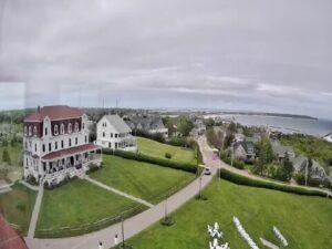
The Lincoln Montana Webcam looks along Main Street in Lincoln, a small town in the upper Blackfoot River valley where Montana Highway 200 is the road through the business district. Two cameras on the front of Rusty Relics, an antiques and art shop at 506 Main Street, face in opposite directions. The east view follows the highway as it curves past a green-roofed roadside building, the direction it takes toward Rogers Pass and the Continental Divide. The west view looks down the valley past a dark-sided building with a stone base, a red barn-style shop and a row of street lamps. Tall pines close in both frames, and pickups pull in and out of the gravel lots. From late autumn into spring the cameras often show snow on the shoulders of the highway and on the trees.
Lincoln is an unincorporated community in western Lewis and Clark County, counted by the census as a place of 998 people in 2020. The town sits at about 1,389 meters (4,557 feet) on the Blackfoot River, and its census area stretches roughly 10 kilometers (6 miles) east up the valley and 5 kilometers (3 miles) west of the center. The name comes from the gold rush. In 1865 David Culp and Thomas Patterson staked a claim in a side valley they called Abe Lincoln Gulch, after the recently assassinated president, and the camp that grew up at the mouth of the gulch shortened it to Lincoln. A permanent post office followed in 1887.
The route through town is older than the town. Meriwether Lewis came this way on his return east in 1806, following the trail Native Americans knew as the River of the Road to the Buffalo. Today it is Montana Highway 200, the longest route signed as a state highway in the United States at 1,137 kilometers (706.6 miles) from Idaho to North Dakota. From Lincoln it runs 124 kilometers (77 miles) west to Missoula and 140 kilometers (87 miles) northeast over the divide to Great Falls. Logging, mining and recreation along the Blackfoot turned Lincoln into a supply stop in the early 20th century, and two buildings from that era, the Hotel Lincoln (1914) and the Lincoln Community Hall (1918), are listed on the National Register of Historic Places.
The cameras are part of Live Stream Montana, a network of central Montana town cams run with Live In MT Real Estate that also covers Conrad, Choteau and Great Falls. In Lincoln they are hosted by Rusty Relics, which sells antiques, art, books, jewelry and maps. The Blackfoot Valley Dispatch reported on the shop’s livestream of downtown in May 2022.
Lincoln has a humid continental climate that borders on semi-arid, with long, snowy winters and short, warm summers. NOAA normals for the Lincoln Ranger Station, 1991 to 2020, put January afternoons near 0°C (32°F) and nights around -11°C (12°F), and the station has recorded a low of -44°C (-48°F). About 38 centimeters (15.1 inches) of snow falls in an average January and 169 centimeters (66.6 inches) across the whole year. The deepest cold in the area belongs to Rogers Pass, up the same highway: it reached -57°C (-70°F) on January 20, 1954, the lowest temperature ever recorded in the United States outside Alaska.
Spring comes late at this altitude. April averages 11°C (53°F) by day and -3°C (27°F) at night, with about 8 centimeters (3.2 inches) of snow still falling. July is the warm, dry month, with highs around 27°C (81°F) and only 21 millimeters (0.82 inches) of rain, yet nights still drop to about 7°C (44°F). October mirrors April at 12°C (54°F) by day and -2°C (28°F) at night, and the first snow of the season often arrives then, about 5 centimeters (2.1 inches) on average. Total precipitation is a modest 477 millimeters (18.77 inches) a year.
The Continental Divide National Scenic Trail passes within 32 kilometers (20 miles) of downtown at three points. Rogers Pass, about 30 kilometers (18.5 miles) out on Highway 200, is where the trail crosses the road the east camera follows. Stemple Pass Road and Flescher Pass on Montana Highway 279 reach the divide east of town, and the Alice Creek Trailhead leads into the Scapegoat Wilderness and on toward the Bob Marshall Wilderness. The Missoula and Great Falls airports are each about 90 minutes away by road.
Closer in, Lincoln has Hooper Park, the outdoor sculpture art of Blackfoot Pathways, the Upper Blackfoot Valley Historical Society museum and a set of local hiking trails. The Blackfoot River itself runs along the valley floor below the highway. The town’s calendar includes the Lincoln Art and Music Festival and a Fourth of July celebration, and Garnet Ghost Town, a gold-era mining camp, makes a longer day trip.
More Main Street and mountain town cameras in Montana and the Rockies:
Lincoln is in western Lewis and Clark County, in the upper Blackfoot River valley on Montana Highway 200. Missoula is 124 kilometers (77 miles) to the west, and Great Falls is 140 kilometers (87 miles) to the northeast, over the Continental Divide at Rogers Pass.
Two views of Main Street, which is Highway 200, from the front of Rusty Relics at 506 Main Street. One camera looks east and the other west, and both take in the highway, roadside businesses, gravel parking lots and tall pines. The player’s tabs switch between the two.
Winters are long and cold, with January highs near 0°C (32°F) and lows around -11°C (12°F). Summers are warm and dry by day, with July highs around 27°C (81°F), but nights still fall to about 7°C (44°F).
The Lincoln Ranger Station averages about 169 centimeters (66.6 inches) of snow a year under the 1991 to 2020 normals, and January is the snowiest month at about 38 centimeters (15.1 inches). Some snow typically falls as early as October and as late as April.
Only through town. The cameras show Main Street, the in-town stretch of Highway 200, so they tell you whether snow is lying on the road in Lincoln itself. Rogers Pass, about 30 kilometers (18.5 miles) away and higher up, can be very different.
Rogers Pass, northeast of Lincoln on Highway 200, recorded -57°C (-70°F) on January 20, 1954, the coldest temperature measured in the United States outside Alaska.
From Abe Lincoln Gulch, where David Culp and Thomas Patterson staked a gold claim in 1865 and named it for the recently assassinated president. The mining camp at the mouth of the gulch shortened the name to Lincoln.
Source: Live Stream Montana
The best new live webcams and site features, once a week.
By subscribing you agree to receive our weekly email. Unsubscribe any time.
 15°C / 59°F
 23.2°C / 73.8°F
 22.2°C / 72°F
 9.8°C / 49.6°F