
Live

 14:29:57
 22.3°C / 72.1°F
 Light Rain
 59%
59% 15 km/h / 9 mph
 07:02
07:02 18:11
18:11Loading forecast…



Catalina Island, Los Angeles County, California, USA
 18°C / 64.4°F
14:29
18°C / 64.4°F
14:29






Big Bear Valley Recreation and Park District, Park Avenue, Big Bear Lake, CA, USA
 13.9°C / 57°F
14:29
13.9°C / 57°F
14:29
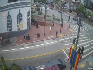
The Skid Row webcam looks down San Julian Street in downtown Los Angeles, inside the 50-block district the city officially calls Central City East. The frame is street level and unedited: a signalized crossing in the middle, a wide sidewalk running along a stone wall to the right, and the roadway carrying traffic away to the left. Green pedestrian signs near the top of the picture point toward the Toy District and the Fashion District, both of which border this area. Three more cameras cover the 500 and 600 blocks of South San Pedro Street, two blocks east, so the same handful of streets can be followed from four angles at once, day and night.
Skid Row sits immediately east of the downtown financial and historic cores, bounded by Third Street to the north, Seventh Street to the south, Alameda Street to the east and Main Street to the west. That works out to about 1 square kilometer (0.39 square miles) of dense, low-rise blocks. City data put the resident population at roughly 10,580, and the district holds one of the largest stable homeless populations in the United States, estimated at more than 4,400 people. The name has no legal standing: on planning documents the area is Central City East.
The pattern goes back more than a century. Residential hotels opened at the end of the 19th century for a transient workforce, and once the railroads went in along the eastern edge of downtown, the farmland beyond turned industrial and drew seasonal laborers who needed a cheap bed between jobs. By the 1930s as many as 10,000 homeless people were living here. Demolitions through the 1960s cut the stock of residential hotel rooms from roughly 15,000 to 7,500, and in 1976 the city made the area an unofficial containment zone where shelters and services would be tolerated. The region’s aid infrastructure has stayed ever since.
Some of that infrastructure is in shot. The Weingart Center, which publishes two of the four feeds here, occupies the former El Rey Hotel at 566 South San Pedro Street, a 1923 building by the architect Charles F. Whittlesey, about 120 meters (390 feet) from the San Julian camera. Two supportive housing towers have gone up beside it: 600 San Pedro, 17 stories and 302 units, and a 12-story building of 104 units on the same block. A 19-story, 278-unit tower on South Crocker Street takes the joint Weingart and Related California program to roughly 700 units.
Downtown Los Angeles has a Mediterranean climate with a long dry season and a short wet one. On the 1991 to 2020 normals for the downtown station, August is the warmest month at an average high of 29 C (84 F) and a low of 18 C (65 F), with July a shade behind at 28 C (82 F). Those figures understate the street. Asphalt, low buildings and very little shade hold the heat well into the evening, which is why the Skid Row webcam often shows more movement on a late August night than at noon. Rainfall in July and August averages under 1.3 millimeters (0.05 inches), so the pavement can stay dry for months at a stretch.
Winter is mild, and almost all of the annual 362 millimeters (14.25 inches) of rain arrives between November and April. Wet days change the picture more than cold ones do: standing water across the roadway, signal heads reflecting off the asphalt, far fewer people on the sidewalks. Spring and autumn sit in between. In late spring the coastal marine layer can hold a flat gray overcast over downtown until midday, so the morning view is often duller than the afternoon one.
Little Tokyo begins about 800 meters (0.5 miles) north and is one of only three historic Japantowns left in the United States, a National Historic Landmark District since 1995. The Japanese American National Museum stands at its eastern edge, and Japanese Village Plaza fills the middle with ramen counters, bakeries and confectioners. Cross Alameda Street heading east and the Arts District starts roughly 900 meters (0.55 miles) out, where old warehouses now hold galleries, coffee roasters and breweries.
Going the other way, Grand Central Market on Broadway has traded since 1917 and sits about 850 meters (0.5 miles) from the cameras, with the 1893 Bradbury Building directly across the street and the Angels Flight funicular a block beyond. The Flower District is closer still, around 600 meters (0.4 miles) south. Union Station is 1.5 kilometers (0.9 miles) north, opened in 1939, and carries the Metro B and D subway lines plus Metrolink and Amtrak, which makes it the usual arrival point for this side of downtown.
Other cameras covering the city and the coast around it:
In downtown Los Angeles, between Third Street and Seventh Street and between Main Street and Alameda Street. Little Tokyo borders it to the north, the Arts District to the east.
Street-level views of San Julian Street and the 500 and 600 blocks of South San Pedro Street: crossings, sidewalk life, passing traffic, tents and outreach vehicles, and whatever the weather is doing to the pavement. Nothing is edited or delayed, and the streetlights keep the picture usable after dark.
Four, switchable from the tabs above the player. One looks along San Julian Street and the other three cover South San Pedro Street from different corners, including a wide view of the crossing outside the Weingart Center.
All four feeds run continuously. Individual cameras do drop out for maintenance or a connection fault, so if one tab comes up black, switch to another.
Warm and dry for most of the year. August averages a high of 29 C (84 F) and a low of 18 C (65 F); January averages 20 C (68 F) by day and 9 C (49 F) at night. April runs to 22 C (72 F) and October to 26 C (79 F).
Two of them are published by the Weingart Center, a homeless services organization at 566 South San Pedro Street. The San Julian Street view and one of the San Pedro Street views are streamed on YouTube by the Spotlight Rescue channel.
The district has long-standing problems with street crime and open drug use, and it is not somewhere to wander after dark. It is also home to thousands of people, so anyone passing through should keep to the main streets in daylight and not photograph residents.
About 1.5 kilometers (0.9 miles), roughly a 20 minute walk south through Little Tokyo.
Source: Weingart Center and Spotlight Rescue
The best new live webcams and site features, once a week.
By subscribing you agree to receive our weekly email. Unsubscribe any time.
 19.6°C / 67.3°F
 24.9°C / 76.8°F