Live

 17:51:26
 12.6°C / 54.7°F
 Clear Sky
 50%
50% 4 km/h / 2 mph
 07:10
07:10 17:46
17:46Loading forecast…

Montreal, Mount Royal, Quebec, Canada
 12.7°C / 54.9°F
17:51
12.7°C / 54.9°F
17:51



Carleton Place, Lanark County, Ontario, Canada
 12.3°C / 54.1°F
17:51
12.3°C / 54.1°F
17:51
Policeman's Creek Boardwalk, Canmore, AB, Canada
 16.7°C / 62.1°F
15:51
16.7°C / 62.1°F
15:51
Steinbach South Airport, Hanover, Manitoba, Canada
15.7°C / 60.3°F
16:51


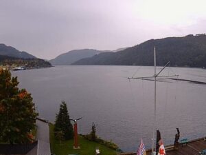
The Ile d’Orleans Marina Webcam looks over the harbor of the Club nautique de l’Ile d’Orleans in Saint-Laurent-de-l’Ile-d’Orleans, the only marina on this island in the St. Lawrence River just east of Quebec City. A flagpole stands at the left edge of the frame and a strip of lawn with benches fills the foreground. Sailboats sit on floating docks behind a rock breakwater on the right, while a long concrete wharf runs out along the left side of the basin. Beyond both, the river opens toward the low line of the south shore, and large ships can pass out on the water, their lights standing out after dark. In low light the picture can switch to black and white, so a gray image at dusk is the camera’s night mode rather than a fault.
The marina sits at 100 chemin du Quai in Saint-Laurent-de-l’Ile-d’Orleans, a village of 1,607 people at the 2021 census on the south side of Ile d’Orleans. Across the river lie Levis, Beaumont and Saint-Michel-de-Bellechasse. The InfoMarina directory lists 134 berths and 5 transient docks, and the club’s harbor office has washrooms, showers and laundry, with fuel for boaters and a mast-stepping crane at the municipal wharf. A few powerboats can be seen tied along the inner face of the wharf, closer to the camera than the sailboat docks.
The harbor dates from the 1980s. A first club, Club nautique de l’Ile d’Orleans Inc., was formed in 1979. On August 12, 1983, a group of 30 boaters founded the Club Nautique de l’Ile Bacchus Inc., which was put in charge of building a marina, and in 1983 and 1984 the federal government built the basin, the dikes, the parking lot and the launch ramp. The visit of the tall ships to Quebec City in 1984 gave the project its push. That same year, club members built the docks, the harbor office and the fuel dock, and ran water and power to the berths.
Boats were part of Saint-Laurent long before the marina. In the 19th century some 15 shipyards in the village built up to 400 rowboats, coasters and schooners a year, and the Saint-Laurent Ltd. shipyard stayed active on the shore from 1905 to 1967. The island as a whole is 34 kilometers (21.1 miles) long and 8 kilometers (5 miles) wide, covers 192.85 square kilometers (74.5 square miles), and has been a National Historic Site of Canada in its entirety since 1990.
The island shares the continental climate of Quebec City, with warm summers and long, snowy winters. July brings average highs near 25 C (77 F) and lows around 13 C (55 F). Summer is when the harbor office keeps its longest hours, staying open until 8 p.m. from June 19 to August 22 instead of closing at 5 p.m. Spring and autumn fall between those extremes, with cooler days at either end of the summer boating months.
January averages highs around -8 C (18 F) and lows near -18 C (0 F), and a winter in the Quebec City area can bring about 3 meters (10 feet) of snow. Snow can cover the lawn and the wharf in front of the camera for much of the winter. The St. Lawrence is tidal here, which is why the club points boaters to the tide table for Saint-Laurent, and on the Ile d’Orleans Marina Webcam the waterline along the wharf wall can sit higher or lower from one visit to the next.
The village’s boatbuilding past is on show at the Parc maritime de Saint-Laurent, now presented as the Musee maritime de l’Ile d’Orleans, on the site of the former Saint-Laurent Ltd. shipyard. Its centerpiece is the Godbout boat shop, built in 1837, where an exhibition explains how wooden rowboats and schooners were made, with a collection of more than 400 heritage tools. Boaters arriving by water can take a transient berth at the club, and trailered boats can use its launch ramp, which is priced by boat length.
Beyond Saint-Laurent, the Chemin Royal, completed in 1744, circles the whole island and links its six municipalities: Sainte-Petronille, Saint-Laurent, Saint-Jean, Saint-Francois, Sainte-Famille and Saint-Pierre. Ile d’Orleans is known as the Garden of Quebec for its strawberries, apples, potatoes, blueberries, raspberries, maple syrup and wine, and the road runs past many of the farms that grow them. The Ile d’Orleans bridge from Beauport, first opened in 1935, connects the island to the mainland, and downtown Quebec City lies about 5 kilometers (3.1 miles) to the west.
More cams on the St. Lawrence and on Canadian marinas:
The marina is at 100 chemin du Quai in Saint-Laurent-de-l’Ile-d’Orleans, on the south side of Ile d’Orleans in Quebec, Canada. The island sits in the St. Lawrence River about 5 kilometers (3.1 miles) east of downtown Quebec City and is reached by the bridge from Beauport.
The camera looks over the club’s basin: sailboats on floating docks behind a rock breakwater on the right, a long concrete wharf on the left, a flagpole and a lawn with benches in the foreground, and the open St. Lawrence with the south shore on the horizon. Large ships can appear on the river beyond the wharf.
Summers are warm, with July highs near 25 C (77 F), and winters are cold and snowy, with January lows around -18 C (0 F). The island follows the Quebec City climate, where a single winter can bring about 3 meters (10 feet) of snow.
Saint-Laurent-de-l’Ile-d’Orleans. The Club nautique de l’Ile d’Orleans runs the island’s only marina there, with 134 berths and 5 transient docks.
The south shore of the St. Lawrence, where Levis, Beaumont and Saint-Michel-de-Bellechasse face the village. That shore forms the low line along the horizon of the camera view.
The current broadcast went live on February 4, 2021, in the middle of a Quebec winter, and the camera has stayed on that same stream since. The harbor office itself keeps daily hours of 8 a.m. to 5 p.m., subject to the weather.
In the 19th century the village had some 15 shipyards building up to 400 rowboats, coasters and schooners a year. The Godbout boat shop from 1837 survives as part of the village’s maritime museum.
Head east from Quebec City to Beauport and cross the Ile d’Orleans bridge, first opened in 1935. From the end of the bridge, the Chemin Royal leads around the island to Saint-Laurent and the marina on chemin du Quai.
Source: Club Nautique de l’Ile d’Orleans
The best new live webcams and site features, once a week.
By subscribing you agree to receive our weekly email. Unsubscribe any time.
 10.9°C / 51.6°F
 8.4°C / 47.1°F