English
 简体中文
 Deutsch
 Français
 Español
 Nederlands
 Svenska
 Italiano
 日本語
 Polski
 Português
 Русский
 Ελληνικά
 العربية
 Türkçe

Live
 19:20:01
 8.6°C / 47.5°F
 Overcast Clouds
 87%
 16 km/h / 10 mph
 07:40
 17:24
Loading forecast…
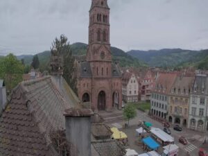
The Arras Webcam looks down on Place des Heros in the heart of Arras, northern France, with the Gothic town hall and its 75-meter (246-foot) belfry rising on the left of the frame. To the right, a long row of gabled Flemish houses runs down the side of the square, their ground floors opening into arcades where cafe tables are set out. The camera belongs to the City of Arras and streams through Viewsurf. Weather changes this view more than anything else. On a clear afternoon the pale stone of the belfry stands out sharply against the sky, while on a wet morning low cloud can swallow the top of the tower and raindrops streak across the lens. Delivery trucks, parked cars and people crossing the paving keep the square moving through the day.
Arras is the prefecture of the Pas-de-Calais department in the Hauts-de-France region, a town of 42,875 people (2023) at an average elevation of 72 meters (236 feet). It sits on the River Scarpe, while the smaller Crinchon runs underground beneath the streets. The historic center is built around two linked squares, the Grand-Place and Place des Heros, framed by 155 townhouses in the Flemish Baroque style dating from the 17th and 18th centuries. Their stepped and curved gables, all slightly different, are what give the right half of the camera’s view its rhythm.
The town hall on the left of the frame was completed in 1517 in a Gothic style modeled on the town hall of Saint-Quentin, and its main front faces Place des Heros. German artillery set it on fire on 7 October 1914, and the belfry behind it came down on 21 October 1914. Around two-thirds of the 155 facades on the two squares were wrecked during the First World War. The town hall and belfry were rebuilt in the 1920s to designs by the architect Pierre Paquet, and the building was listed as a French historic monument in 1921.
At 75 meters (246 feet), the belfry is the tallest structure in Arras, and its clock face and crowned top are plain to see on the Arras Webcam whenever the cloud is high enough. In 2005 UNESCO added it to the World Heritage List as part of the Belfries of Belgium and France. Under the square lie the boves, chalk tunnels about 10 meters (33 feet) below the streets that were dug in the Middle Ages and used as shelters in both world wars.
Winters in Arras are cool and grey rather than harsh. January averages highs of 6.2°C (43°F) and lows of 1.3°C (34°F) on the 1991 to 2020 normals, and snow settles on only a handful of days in a typical year. Daylight is short in late December, at about 8 hours, and the sun sets before 5 pm, so the town hall facade is often in flat, low light even at midday. Spring warms slowly, with April highs around 14°C (57°F) and lows near 5°C (41°F).
Summer is mild, with July averaging highs of 23.6°C (75°F) and lows of 13.1°C (56°F). Late June brings more than 16 hours of daylight, so the square stays bright well into the evening. October is still fairly mild at around 16°C (61°F) by day and 9°C (48°F) at night. Rain is spread through the whole year, about 711 millimeters (28 inches) in total, and a damp autumn morning can hide the top of the belfry completely, as it did on the Arras Webcam on the November morning it was added to the site.
The building in the camera’s frame is also the way underground: the boves are reached through the basement of the town hall, which makes the town hall the natural first stop. The Grand-Place, the other half of the historic center, is a short walk away and is lined with the same kind of arcaded Flemish houses. Farther out, the Citadel of Arras was built by Vauban between 1667 and 1672. Since 2008 it has been part of the Fortifications of Vauban World Heritage listing, which gives Arras a second UNESCO site alongside its belfry.
Wellington Quarry (Carriere Wellington) tells the story of the Battle of Arras from about 20 meters (66 feet) below the pavements. New Zealand tunnellers worked on the old chalk quarries under the town from late 1916 to prepare for the British spring offensive of 1917, and the site opened as a museum in 2008. About 11 kilometers (6.8 miles) from town, the Canadian National Vimy Memorial stands on Vimy Ridge above the plain north of the town.
If you like watching an old town square, these cameras are worth a look next.
Arras is in the Pas-de-Calais department of the Hauts-de-France region in northern France. In a straight line it lies about 42 kilometers (26 miles) southwest of Lille and about 160 kilometers (100 miles) north of Paris. The camera looks over Place des Heros in the town center.
The camera looks across Place des Heros to the town hall and its belfry on the left, with a row of gabled Flemish Baroque houses and their ground-floor arcades on the right. The open square in front is usually busy with parked cars, delivery vans and people on foot.
Arras has cool, damp winters and mild summers. January averages highs of 6.2°C (43°F), July averages highs of 23.6°C (75°F), and about 711 millimeters (28 inches) of rain falls through the year, so wet days can come in any season.
The belfry is 75 meters (246 feet) tall, the highest structure in Arras. The tower seen today is the rebuilt one: the original collapsed on 21 October 1914 under German shelling and was reconstructed in the 1920s.
Yes. UNESCO added the Arras belfry to the World Heritage List in 2005 as part of the Belfries of Belgium and France. The town has a second listing too, as its Vauban citadel joined the Fortifications of Vauban site in 2008.
German artillery set the town hall on fire on 7 October 1914, and the belfry fell two weeks later. Both were rebuilt in the 1920s to designs by Pierre Paquet, so the Gothic facade on the camera is a reconstruction of the building first completed in 1517.
The boves are medieval chalk tunnels about 10 meters (33 feet) beneath the center of Arras. They served as shelters in both world wars and can be reached from the basement of the town hall seen on the camera.
Source: City of Arras
The best new live webcams and site features, once a week.
By subscribing you agree to receive our weekly email. Unsubscribe any time.


 9.2°C / 48.6°F

 -0.3°C / 31.5°F




 14.2°C / 57.6°F