
 English
 简体中文
 Deutsch
 Français
 Español
 Nederlands
 Svenska
 Italiano
 日本語
 Polski
 Português
 Русский
 Ελληνικά
 العربية
 Türkçe
Live
 12:12:44
 9.8°C / 49.6°F
 Clear Sky
 95%
 7 km/h / 4 mph
 07:55
 17:54
Loading forecast…
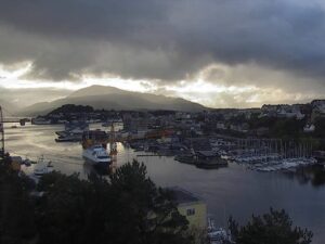
The Binic Webcam looks down the length of the marina in Binic, a small harbor town on the Bay of Saint-Brieuc in Brittany, northwest France. Yacht masts crowd most of the frame, tall stone houses line the quay road on the left, and at the far end the channel runs out past the small light on the Penthievre jetty toward the open bay. A green headland closes the view on the right. The tide changes this scene more than anything else. The wet basin holds its water, but the outer harbor beyond it dries out at low tide except for a channel, so the flats on the right come and go with the sea. Cars circle a roundabout in the foreground.
Binic grew up at the mouth of the Ic, the small river whose name is part of the town’s own. It covered 5.96 square kilometers (2.3 square miles) and had about 3,800 residents in 2014, and on 1 March 2016 it merged with its neighbor to form Binic-Etables-sur-Mer. The camera is run by Vision-Environnement with thanks to the town, and the operator lists the location at 8 meters (26 feet) above sea level.
The harbor was built for fishing, not for leisure. Binic petitioned the Duke of Penthievre for a proper sea wall in 1651, and the stone jetty that carries his name stands 8.6 meters (28 feet) above the beach and 29.7 meters (97 feet) wide at its base, with rubble packed behind dressed stone. Storm damage forced repairs, and the works were signed off in 1855. The round stone light at its head, the small tower at the end of the channel on camera, was designed by the engineer Reynaud, built in 1853 and first lit on 20 March 1854. It burned mineral oil until it was electrified in 1949.
In 1845 Binic was France’s leading port for the Grande Peche, the long voyages to the cod grounds, with 150 to 160 ships a year working the Newfoundland fishery and the coastal trade. Schooners became the town’s signature boats from the 1860s, but fishing off Newfoundland and Iceland declined in the first quarter of the 20th century and the schooners disappeared. The granite and schist houses the shipowners built still line the Quai Jean Bart. Since 1992 the local trawlers have landed their catch at Saint-Quay-Portrieux, and the basin on camera is now a marina with 500 berths afloat that takes more than 600 boats on its pontoons and moorings. The outer harbor covers 4 hectares (9.9 acres), the wet basin 3.35 hectares (8.3 acres), and the two share 1,300 meters (4,265 feet) of quays.
Binic has a mild climate shaped by the sea. The nearest long-run figures come from Saint-Brieuc, where the 1991 to 2020 normals give January days of 8.9 C (48 F) and nights of 3.8 C (39 F). Spring warms slowly, and April still averages only 13.6 C (56 F) by day and 6 C (43 F) at night. In July and August highs reach 21.4 to 21.6 C (71 F) with nights around 13 C (55 to 56 F), and the beach beside the outer harbor has lifeguards in those two months only.
Autumn stays mild for a long time: October averages 15.8 C (60 F) by day and 9.4 C (49 F) at night. Saint-Brieuc records about 757 millimeters (29.8 inches) of rain and 1,616 hours of sunshine a year, so a low gray sky over the masts is a common sight in every season. Daylight swings widely at this latitude, from about 16 hours around the June solstice to about 8 hours 15 minutes in late December, so winter afternoons on camera turn dark early.
The GR34 coastal path, the old customs officers’ trail known as the Sentier des Douaniers, links Binic’s port, quays and beaches, so you can walk from the quays on camera out along the coast. The town has three beaches: the outer harbor beach between the jetty and Rognouse point, reached by a small path cut into the cliff, then La Banche and the Plage du Corps de Garde. A market fills the harbor every Thursday.
In town, the Musee des Traditions Populaires de Binic keeps the town’s local traditions, and the church of Notre-Dame-de-Bon-Voyage and the chapel of Saint-Gilles are both within Binic. The viaducts of La Hasee and Beaufeuillage survive from the railway that once served the town. Saint-Quay-Portrieux is the next harbor north, 6 kilometers (3.7 miles) away, and Saint-Brieuc lies about 11 kilometers (7 miles) to the south.
More harbors on both sides of the English Channel, plus another stretch of the French coast:
Binic is on the western shore of the Bay of Saint-Brieuc in the Cotes-d’Armor department of Brittany, in northwest France. It is part of the commune of Binic-Etables-sur-Mer, about 11 kilometers (7 miles) north of Saint-Brieuc and 6 kilometers (3.7 miles) south of Saint-Quay-Portrieux.
The camera looks along the marina basin toward the harbor mouth. Moored yachts fill the right and center, the quay road and a row of tall stone houses run along the left, and the Penthievre jetty light marks the end of the channel, with a headland across the water on the right.
Mild for most of the year. Saint-Brieuc’s 1991 to 2020 normals give winter highs near 9 C (48 F) and summer highs near 21 C (70 F), with about 757 millimeters (29.8 inches) of rain a year.
Yes, on the right of the frame. The wet basin with the yachts keeps its water, but the outer harbor dries out at low tide apart from a channel, so sand and flats appear beyond the harbor wall and disappear again as the sea comes back in.
It is the light on the head of the Penthievre jetty, a round stone tower designed by the engineer Reynaud, built in 1853 and first lit on 20 March 1854. A spiral staircase of 45 steps runs inside. It switched from mineral oil to electricity in 1949, and its grounds are open to the public.
In 1845 it was France’s leading port for the Grande Peche, sending 150 to 160 ships a year to the Newfoundland fishery and the coastal trade. The shipowners’ granite and schist houses on the Quai Jean Bart are a legacy of that trade, which faded in the early 20th century.
The town has three: the outer harbor beach just past the jetty, which has lifeguards in July and August, La Banche, and the Plage du Corps de Garde. The GR34 coastal path joins all of them to the port.
Source: Vision-Environnement
The best new live webcams and site features, once a week.
By subscribing you agree to receive our weekly email. Unsubscribe any time.



 7.4°C / 45.3°F
 5.6°C / 42.1°F
 11.1°C / 52°F

 10.8°C / 51.4°F

