Live

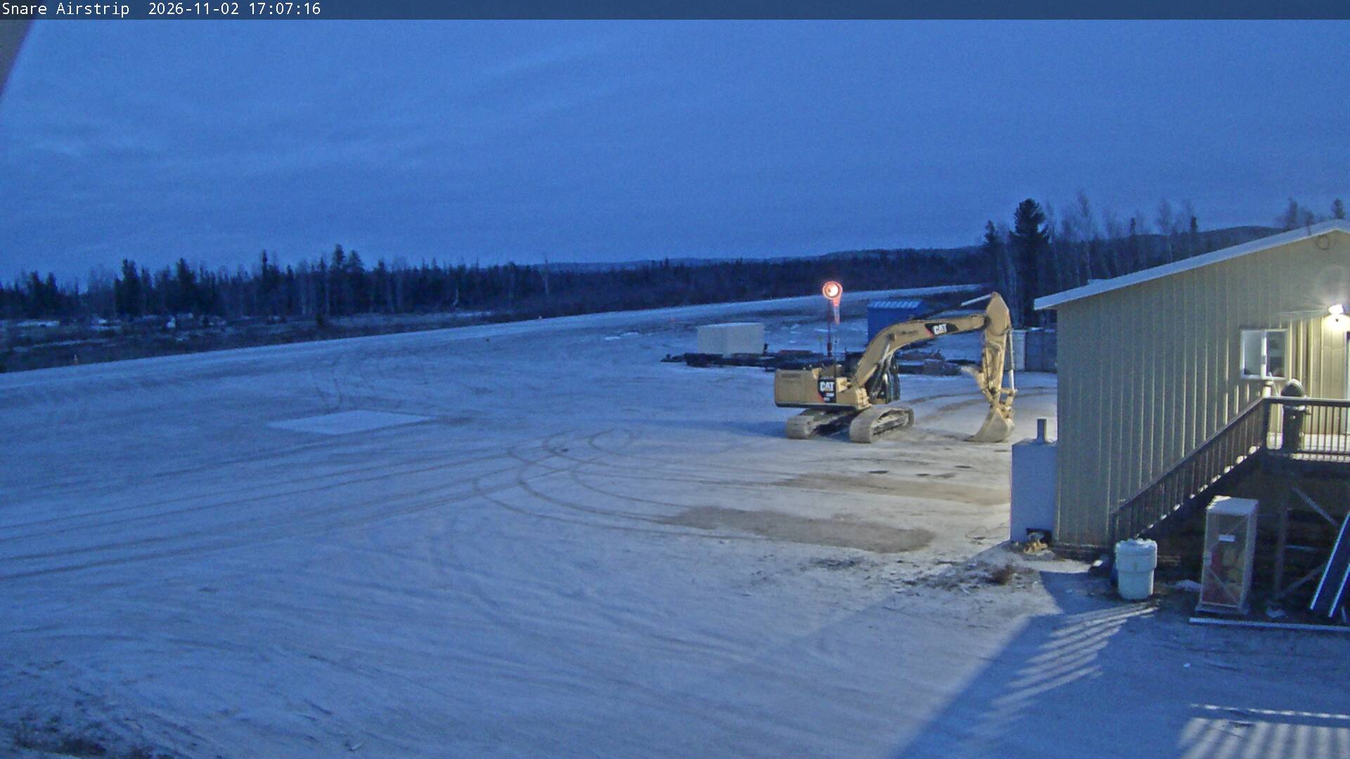
Stream hours: A new still image arrives about every 5 minutes. In midwinter the sun is up for only about four and a half hours a day, so the picture is dark most of the time.
 12:00:37
 -2.1°C / 28.2°F
 Overcast Clouds
 72%
 9 km/h / 6 mph
 08:44
 18:14
Loading forecast…
Planes on the ground and in the air within about 22 km (14 miles) of the airport, updated every 10 seconds. Tap a plane or a flight in the list for its details. Altitudes are above sea level. Positions come from volunteer ADS-B receivers, so some airports show few or no planes on the ground.
The Snare Hydro Webcam looks across a sandy apron to Snare River Airport, the small airstrip beside the Snare Falls power plant, about 140 kilometers (87 miles) northwest of Yellowknife in Canada’s Northwest Territories. White pickups and a wheel loader sit in front of shipping containers and an orange windsock, and a pale green building fills the right edge of the frame. Beyond the strip, a long line of spruce and bare birch runs out to low hills on the horizon. A second camera, labelled Hill, looks past sheds and a boom lift to a stand of white-trunked birch below a rocky ridge. Both are still images from a weather station at 213 meters (699 feet), so the snow, the light and the vehicles outside change from one picture to the next.
Snare Hydro is the name for four hydroelectric plants on the Snare River, built in stages to power Yellowknife. The first, at Snare Rapids, was commissioned in 1948 with 8 megawatts for the Giant and Consolidated gold mines and the young town. Montreal Engineering Company designed it and Northern Construction Company built it, with materials flown in at great expense or hauled in winter by trains of bulldozers pulling large sleds. The earth dam’s frozen core material held so much excess moisture that it took a long time to dewater. Snare Falls followed in 1961, Snare Forks in 1975 and Snare Cascades in 1996. The Canadian Society for Civil Engineering unveiled a historic site plaque for the system on June 8, 2007.
The Northwest Territories Power Corporation runs the plants today. Its figures give Snare Rapids an 8.5 MW generator plus a 500 kW unit, Snare Falls a 7.5 MW generator, Snare Forks two 4.5 MW generators and Snare Cascades a 4.3 MW generator, the last leased from the Dogrib Power Corporation. Together that comes to about 27.3 MW, sent to Yellowknife, Behchoko and Dettah over roughly 150 kilometers (93 miles) of transmission line. From the camera, the Snare Falls plant is about 600 meters (2,000 feet) away, Snare Cascades lies about 3 kilometers (1.9 miles) downstream and Snare Rapids about 12 kilometers (7.5 miles) upstream.
The strip in the main view is Snare River Airport, a single sand runway numbered 11/29 and about 914 meters (3,000 feet) long, operated by the power corporation. The weather station that carries both cameras is part of LW-APP, a network run by CasCom, a technology and communications company headquartered in Yellowknife. Below the plants, the Snare River’s water continues to Great Slave Lake by way of Marian Lake and Frank Channel.
Winters here are long and severe. Model data for the site puts January highs around -22 C (-7 F) and lows near -28 C (-19 F), close to Yellowknife’s January averages of -21.6 C (-7 F) and -29.4 C (-21 F). The apron and the runway are typically white from late autumn into spring. Daylight is the bigger limit for this camera: around the December solstice the sun is up for only about four and a half hours and climbs barely 3 degrees above the horizon at noon, so the picture stays dim for most of the day. March brings longer days but highs still near -13 C (8 F), and April only reaches about -3 C (27 F).
The thaw comes quickly. May highs jump to about 11 C (53 F), and by July the site averages about 22 C (72 F) by day and 13 C (56 F) at night, with the sun up for roughly 20 and a half hours around the June solstice. July and August are the wettest months, August most of all at about 55 millimeters (2.2 inches) in the model record. September highs fall back to about 12 C (53 F), and by mid-October, when the birch on both cameras are already bare, highs are near 1 C (35 F) with lows around -3 C (27 F).
Snare Hydro is a working power site rather than a visitor attraction, so a trip into this part of the North Slave Region starts from one of the communities its plants supply. The nearest is Behchoko, about 72 kilometers (45 miles) to the south, where Frank Channel carries the Snare River’s water on toward Great Slave Lake. Dettah, the third community on the Snare grid, lies about 6 kilometers (4 miles) southeast of Yellowknife.
Yellowknife, about 140 kilometers (87 miles) to the southeast, is where most visitors base themselves. The Prince of Wales Northern Heritage Centre, a museum on 48th Street downtown, is a good first stop, and the Old Town district lies about 1.6 kilometers (1 mile) to its northeast. The Ingraham Trail (Highway 4) runs east from the city as an all-weather road, and Cameron Falls lies about 36 kilometers (22 miles) east of Yellowknife along it. Many visitors come to Yellowknife for the Northern climate and traditional lifestyle, and to see the aurora.
For more of the North and its small airfields, try these next.
Snare Hydro is on the Snare River in the North Slave Region of the Northwest Territories, Canada, about 140 kilometers (87 miles) northwest of Yellowknife. The weather station that carries the cameras stands at 213 meters (699 feet), next to the Snare Falls plant and Snare River Airport.
The main Air Strip camera shows the sand apron and runway of Snare River Airport, parked trucks, containers, a windsock and a line of boreal forest. The Hill tab looks over sheds and work equipment to birch, spruce and a rocky ridge behind the site.
Usually because it is night at the camera. At 63 degrees north the winter days are very short, with about four and a half hours of daylight around the December solstice, so the picture is dark for much of the day from late autumn to midwinter. Each frame shows its capture time, in Mountain Time, in the top-left corner.
Cold and fairly dry for most of the year. January highs average around -22 C (-7 F) and July highs around 22 C (72 F), with most of the rain falling in July and August.
The Northwest Territories Power Corporation, a subsidiary of NT Hydro, which is wholly owned by the Government of the Northwest Territories. Snare Cascades is leased from the Dogrib Power Corporation.
Snare Rapids came first, commissioned in 1948 to power Yellowknife’s gold mines. Snare Falls was added in 1961, Snare Forks in 1975 and Snare Cascades in 1996.
About 914 meters (3,000 feet). It is a single sand runway, numbered 11/29, operated by the Northwest Territories Power Corporation.
The best new live webcams and site features, once a week.
By subscribing you agree to receive our weekly email. Unsubscribe any time.





 11.6°C / 52.9°F


 14.1°C / 57.4°F