Live

 15:05:26
 12.8°C / 55°F
 Overcast Clouds
 62%
62% 24 km/h / 15 mph
 07:34
07:34 18:21
18:21Loading forecast…

Baccaro Point, Barrington, Nova Scotia, Canada
12.9°C / 55.2°F
15:05







Banff Centre for Arts and Creativity, Tunnel Mountain Drive, Banff, AB, Canada
4.1°C / 39.4°F
12:05
Apex Mountain Resort, Strayhorse Road, Hedley, BC, Canada
0.4°C / 32.7°F
11:05
The Truro Tidal Bore Webcam looks out from the Fundy Discovery Site in Lower Truro, Nova Scotia, over the Salmon River where it meets Cobequid Bay at the head of the Bay of Fundy. Twice a day the incoming tide pushes up the river against its current, and the leading edge of that water arrives as a single wave, the tidal bore. In the foreground are the site’s curved stone steps, a pair of red and yellow Adirondack chairs and a gravel path along the bank. Beyond them the river bends away toward farmland on the far shore. The scene rarely looks the same twice: a wide channel of red-brown water at high tide can drain to bare mudflats a few hours later, then fill again as the next tide comes in.
A tidal bore forms when a rising tide funnels into a narrowing river and moves upstream as a visible wave. The Bay of Fundy is the right place for it. The Fundy Discovery Site puts the bay’s tidal range at up to 16 meters (52 feet), with around 160 billion tonnes of water surging up the narrowing bay on each tide. The Salmon River rises in the Cobequid Hills of Colchester County and empties into Cobequid Bay between Lower Truro and Lower Onslow. The bore runs up its lower reach every day as far as the head of the tide at Truro, and the size and timing of the wave shift through the month with the tides.
The Fundy Discovery Site is owned and operated by the Municipality of Colchester and sits just off Highway 102 at exit 14, a few minutes from downtown Truro and about 65 kilometers (40 miles) from Halifax Stanfield International Airport. It is part of the Cliffs of Fundy UNESCO Global Geopark, whose rocks record some 300 million years of geological history. The Visitor Centre is staffed from May to October, and the staff there give out tidal bore and tide times for the day. The site also has a natural playground modeled on the Fundy ecosystem, picnic areas and a panoramic lookout, which is roughly the view this camera takes.
Truro itself had 12,954 residents at the 2021 census, and the river mouth in front of the camera is the last stretch of water before the tide reaches the town. The Salmon River has a long record of spring ice jams, and the 1869 Saxby Gale flooded its lower valley.
Truro has cold winters and warm, fairly short summers. January averages a daily high of about -1.4 C (29 F) and a low of -12.4 C (10 F), and the town gets roughly 215 centimeters (85 inches) of snow a year. In late winter and spring the Salmon River is prone to ice jams as the snowmelt comes down from the Cobequid Hills. Total precipitation comes to about 1,183 millimeters (47 inches) a year.
July brings average highs near 24 C (75 F) and lows around 13 C (55 F). That is when the Visitor Centre is open and the path in front of the camera fills with walkers. Spring and autumn sit in between, and the tides keep their twice-daily rhythm in every season. The Discovery Site recommends staying for sunset, when the sky over the mudflats can turn orange and pink.
The Cobequid Trail starts close to the camera. This walking and cycling network runs through Truro and Colchester County along former railway corridors, farmland and forest, and from Lower Truro it follows the tidal Salmon River west to the Cobequid Bay Lookoff. In town, Victoria Park has waterfalls, old-growth forest, hiking and biking trails, playgrounds and the Jacob’s Ladder staircase.
For food, the Truro Farmers’ Market runs year-round, and Masstown Market sells local produce, baked goods, seafood and ice cream. The Millbrook Cultural and Heritage Centre covers Mi’kmaw history and culture with interactive displays. To see the tides from a different angle, drive along the south shore of the Minas Basin to Burntcoat Head, which is known for the highest tides in the bay.
These cameras follow more of the Fundy tides and the Atlantic Canadian coast.
The camera is at the Fundy Discovery Site in Lower Truro, Colchester County, Nova Scotia, Canada, where the Salmon River flows into Cobequid Bay. It is off Highway 102 at exit 14, a few minutes from downtown Truro and about 65 kilometers (40 miles) from Halifax Stanfield International Airport.
The camera looks across the Discovery Site’s stone steps, a gravel path and a pair of Adirondack chairs to the Salmon River as it curves toward Cobequid Bay, with farmland and a line of trees on the far bank. Depending on the tide, the river is either a broad channel of red-brown water or a stretch of exposed mudflats.
Winters are cold and snowy, with January highs around -1.4 C (29 F) and about 215 centimeters (85 inches) of snow a year. Summers are mild to warm, with July highs near 24 C (75 F).
The bore comes up the Salmon River twice a day, following the tides, so the time moves later each day. Predicted arrival times are published by the Canadian Hydrographic Service and posted by the Fundy Discovery Site, and the Visitor Centre staff give them out between May and October.
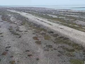
At low tide most of the water drains out of the lower Salmon River, leaving mudflats and a narrow channel. The river refills within hours as the next tide pushes in behind the bore, so an empty riverbed usually means the tide is out, not that the camera has a problem.
The Bay of Fundy has the highest tides on Earth. The Fundy Discovery Site gives a tidal range of up to 16 meters (52 feet) between low and high water, driven by around 160 billion tonnes of water moving in and out of the bay on each tide.
The Fundy Discovery Site is the main public viewing spot, with information panels on the bore, a lookout over the river mouth and washrooms. The Cobequid Trail along the Salmon River gives other vantage points farther upstream.
Source: Nova Scotia Webcams
The best new live webcams and site features, once a week.
By subscribing you agree to receive our weekly email. Unsubscribe any time.
 19.2°C / 66.6°F
 5°C / 41°F