Live
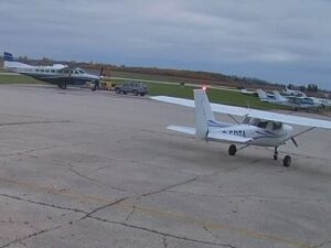
St. Andrews Airport, Winnipeg, Manitoba
St. Andrews Airport, St. Andrews, Manitoba, Canada
 8.7°C / 47.7°F
 15:54
15:54 15:54:51
 8.1°C / 46.6°FOvercast Clouds
 86%
86% 15 km/h / 9 mph
 07:47
07:47 18:36
18:36Loading forecast…
St. Andrews Airport, St. Andrews, Manitoba, Canada
8.7°C / 47.7°F
15:54


Montreal, Mount Royal, Quebec, Canada
11.2°C / 52.2°F
16:54
Rainbow Bridge, Niagara Falls, Ontario, Canada
12.5°C / 54.5°F
16:54


Whistler Olympic Plaza, Blackcomb Way, Whistler, BC, Canada
8.8°C / 47.8°F
13:54
St. John's, Avalon Peninsula, Newfoundland, Canada
12.5°C / 54.5°F
18:24


Planes on the ground and in the air within about 22 km (14 miles) of the airport, updated every 10 seconds. Tap a plane or a flight in the list for its details. Altitudes are above sea level. Positions come from volunteer ADS-B receivers, so some airports show few or no planes on the ground.
The Steinbach South Airport Webcam looks down over the hangars, apron and fuel tanks of Harv’s Air, a family-run flight school on a private airfield 3.2 kilometers (2 miles) south of Steinbach, Manitoba. The operator calls this camera its tower view. Two large grey hangars stand across a wide patched apron, one with a broad door that can stand open through the day, light aircraft park on the grass beside the buildings, and a belt of woods closes off the back of the frame. Over a day the camera can catch the routines of a working flight school: a yellow single-engine plane taxiing between the hangars, or a red fuel truck parked beside the tanks. A second camera, mounted at the Adam Hangar and looking south, covers another stretch of the ramp from a lower angle.
Steinbach South Airport is a registered private aerodrome on Highway 12 in the Rural Municipality of Hanover, run by Harv’s Air Service, and visiting pilots need prior permission to land. Harv’s Air makes a point of saying it is not at Steinbach North, the town’s other airfield. The field sits 271 meters (888 feet) above sea level and has two runways. Runway 18/36 is 949 meters (3,112 feet) long and 30 meters (100 feet) wide, grass with a 7.6 meter (25 foot) asphalt strip down the middle, and runway 07/25 is 559 meters (1,834 feet) of turf. Pilots in the circuit talk to each other on the UNICOM frequency, 122.7, and the field’s identifier is CKK7.
Harv’s Air has offered flight training, air taxi work and aircraft maintenance under the same owner since 1973, from this field and from a second base at St. Andrews Airport north of Winnipeg. The school’s practice area sits directly above the airport, and every aircraft in its fleet is stored in a hangar. That fleet runs from basic trainers and multi-engine aircraft to taildraggers and aerobatic airplanes, all maintained by the company’s own approved maintenance organization. Students in active training can live on the airport grounds in trailers, which the school describes as about 61 meters (200 feet) from the flight line.
Steinbach, 58 kilometers (36 miles) southeast of Winnipeg, had 17,806 residents in the 2021 census. Eighteen Plautdietsch-speaking Mennonite families from the Borosenko colony in Ukraine settled it in 1874, and the city, where Highways 12 and 52 meet, still goes by the nickname The Automobile City.
Winter here is long and hard. January averages a high of -11.1 C (12 F) and a low of -22 C (-8 F), and about 107 centimeters (42 inches) of snow falls in a typical year, so the grass and apron on the Steinbach South Airport Webcam can stay white for months. The airport offers plug-in facilities, the electrical outlets that keep aircraft engines warm enough to start on a frozen morning, along with tie-downs and extended parking for visiting aircraft.
Summers are warm, with July averaging a high of 25.4 C (77.7 F) and a low of 12.5 C (54.5 F), and the city sees about 580 millimeters (22.9 inches) of precipitation a year, rain and snow together. In mid-October the trees behind the hangars turn yellow while the grass between the fuel tanks is still green.
The Mennonite Heritage Village in Steinbach draws about 47,000 visitors a year. It is a 16 hectare (40 acre) outdoor museum laid out as a late 1800s Mennonite village, with a blacksmith shop, a general store and a windmill that is one of the only working wind-powered grain mills in Canada. The Livery Barn Restaurant on the grounds serves traditional Mennonite food, with bread baked from flour ground on site. The outdoor village opens from May 1 to October 1, and the indoor galleries stay open all year.
Harv’s Air itself sells discovery flights, a first lesson at the controls, as well as airplane rides, so the field on camera is also somewhere you can book a seat. In autumn, Penner Pumpkins and the Scarecrow Forest near Steinbach runs a pumpkin patch, corn maze, zip line and petting zoo, and Quarry Oaks Golf Course is one of several courses around the city. In town, A.D. Penner Park holds the baseball diamonds and the Steinbach Arts Council’s Hall Gallery shows local visual art. Farther south, near Vita, lies the Manitoba Tall Grass Prairie Preserve.
For more from Manitoba, small airfields and the northern plains, try these next.
The airport is on Highway 12, 3.2 kilometers (2 miles) south of Steinbach in southeastern Manitoba, Canada. Steinbach is 58 kilometers (36 miles) southeast of Winnipeg, and Harv’s Air suggests driving there on Highways 59 and 52, or Highways 1 and 12.
The main tower view looks down on two large hangars, a patched apron, fuel tanks on the grass and the light aircraft parked around them, with woods along the back of the frame. The Adam Hangar camera looks south across another part of the ramp from beside a hangar wall.
Expect cold, snowy winters and warm summers. January averages -11.1 C (12 F) by day and -22 C (-8 F) at night, July reaches 25.4 C (77.7 F) by day, and about 107 centimeters (42 inches) of snow falls each year.
Harv’s Air is at Steinbach South Airport, 33149 Road 33 North, south of the city off Highway 12. The school says plainly that it is not at the Steinbach North airport, so check the address before you set off.
Yes. Harv’s Air trains pilots from here and from St. Andrews, from a first discovery flight through the Recreational Pilot Permit, Private Pilot Licence and Commercial Pilot Licence, plus night, multi-engine, instrument and aerobatic ratings. Recreational courses can start at any time and run at your own pace.
Runway 18/36 is 949 meters (3,112 feet) long, turf with an asphalt center strip, and runway 07/25 is 559 meters (1,834 feet) of turf. Both are 30 meters (100 feet) wide and have low-intensity threshold and runway-end lights.
The stream is relayed through rtsp.me, whose player pauses after 10 minutes of viewing. Press play again and the live picture returns.
Source: Harv’s Air
The best new live webcams and site features, once a week.
By subscribing you agree to receive our weekly email. Unsubscribe any time.
 8.5°C / 47.3°F
 1°C / 33.8°F
 9.4°C / 48.9°F
 11.9°C / 53.4°F