English
 简体中文
 Deutsch
 Français
 Español
 Nederlands
 Svenska
 Italiano
 日本語
 Polski
 Português
 Русский
 Ελληνικά
 العربية
 Türkçe

Live
 08:35:00
 0.5°C / 32.9°F
 Scattered Clouds
 88%
 13 km/h / 8 mph
 09:28
 13:49
Loading forecast…
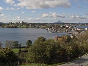
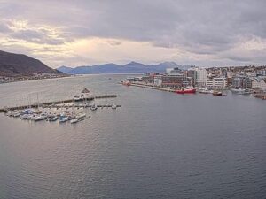
The Harstad Webcam looks down on Harstad from Samaasen, a hillside above the town in Arctic Norway. Dark conifers fill the lower right corner, rooftops and streets spread across the foreground, and past them the harbor opens onto Vagsfjorden, with a wooded hill on the far side of the bay and a line of mountains along the horizon. Boats can be seen crossing the open water to the left. Two tabs add closer views: Harstad kommune’s camera over the floating piers and quays of the harbor basin, and a wide lens over Stornes and Bergseng toward the island of Grytoya. In midwinter the scene runs on a few hours of blue twilight and the town’s lights. In early summer the sun never leaves it.
Harstad sits on the northeastern shore of Hinnoya, Norway’s largest coastal island (only three Svalbard islands are bigger), and faces Vagsfjorden. Locals call it the pearl of Vagsfjorden. The town had 21,289 residents in 2023 on 11.45 square kilometers (4.4 square miles), and the wider Harstad Municipality counted 25,056 people in 2024. Harstad received town privileges as a ladested on 1 January 1904, and at 68.8°N it lies about 250 kilometers (155 miles) north of the Arctic Circle.
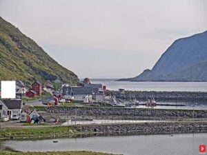
The main camera is the Samaasen stream from LA1H, live on YouTube since January 2025. It takes in most of the town at once: the harbor basin with a long pier reaching into it, large flat roofs near the water, housing that climbs toward the camera, and the open fjord with the mountains beyond. Harstad kommune runs the Town Harbor camera, which has streamed since April 2020 from a rooftop beside the water. Its frame holds a row of floating boat piers on the left, a work boat moored along a quayside promenade on the right, and older gabled buildings and a taller modern block across the basin. The Stornes and Grytoya tab, also from LA1H, uses a wide lens high on a wooded slope, looking down on the houses of Stornes and Bergseng along the shore and out across the water to Grytoya.
Trondenes, on the northern edge of town, holds Harstad’s oldest landmark. Trondenes Church was finished shortly after 1434, a date fixed by tree-ring analysis, and is counted as the world’s northernmost surviving medieval building. Nearby Trondenes Fort keeps the Adolf Gun, a 40.6 centimeter (16 inch) coastal gun from World War II with a barrel more than 20 meters (66 feet) long and a reach of up to about 56 kilometers (35 miles).
Winters in Harstad are milder than the latitude suggests. At the Harstad stadion weather station, 45 meters (148 feet) above sea level, January averages a high of 0.2°C (32°F) and a low of -4.5°C (24°F), and February is much the same. January is also the wettest month, with 129 millimeters (5.1 inches) of precipitation. The polar night lasts from about 30 November to 12 January. The sun stays below the horizon, and the Samaasen camera spends those weeks in a short spell of blue twilight around midday, with the town’s street lights doing the rest.
Spring warms slowly, with average highs of 5.5°C (42°F) in April and 10.5°C (51°F) in May. The midnight sun runs from about 22 May to 18 July, so in early summer the fjord stays lit on camera through the night. July is the warmest month, averaging 17.6°C (64°F) by day and 10.6°C (51°F) at night, and June is the driest, at 39 millimeters (1.5 inches). Autumn brings the rain back, with October highs of 7.1°C (45°F) and November highs of 3.6°C (38°F). The station’s records run from 31.7°C (89°F) in July to -16.1°C (3°F) in February, and the year adds up to 912 millimeters (36 inches) of precipitation.
Trondenes Church and the Trondenes Historical Center stand side by side on the northern edge of town, and the Adolf Gun at Trondenes Fort is seen on guided tours. Each June the town hosts the week-long Festival of North Norway. In the center, a promenade runs along the harbor and the quays that fill the Town Harbor camera.
For a view close to the webcam’s, Gangsastoppen is a short, easy climb from a parking area on Toppenveien, up a staircase to an observation deck that looks all the way around the town and fjord. It is about an hour’s walk from the center. Folkeparken, close to the center, has well-marked forest trails, and the Keipen hike ends at a high lookout. Harstad/Narvik Airport at Evenes, 44 kilometers (27 miles) south of town, has regular flights to Oslo, Trondheim, Bodo and Tromso.
More towns and fjords in northern Norway, from Tromso and Narvik to the outer coast of Senja:
Harstad is in Troms county in northern Norway, on the northeastern shore of Hinnoya facing Vagsfjorden. It lies about 250 kilometers (155 miles) north of the Arctic Circle.
The main camera looks down from Samaasen over the rooftops and harbor to Vagsfjorden and the mountains across it. The Town Harbor tab shows the harbor basin up close, with floating boat piers, a quayside promenade and the waterfront buildings opposite. The Stornes and Grytoya tab looks over two villages along the shore to the island of Grytoya.
Yes. The Town Harbor tab is Harstad kommune’s own harbor camera, streaming since April 2020 from a rooftop beside the water. The main Samaasen camera also shows the whole harbor basin from above, with the long pier and the open fjord beyond it.
No. The airport is at Evenes in Nordland, 44 kilometers (27 miles) south of the town and well out of sight of all three cameras, which cover the town, its harbor and the shore toward Grytoya.
January and February average highs near 0°C (32°F) and lows around -4.5°C (24°F). Highs reach 10.5°C (51°F) in May and peak at 17.6°C (64°F) in July, then fall to 7.1°C (45°F) in October and 3.6°C (38°F) in November, when lows sit just below freezing at -0.7°C (31°F). January is the wettest month and June the driest.
For about six weeks, yes. The polar night lasts from about 30 November to 12 January, when the sun does not rise. The camera still shows a few hours of blue twilight around midday, and the town’s lights keep the harbor visible the rest of the time. In return, the midnight sun keeps the view lit around the clock from about 22 May to 18 July.
Harstad is known for Trondenes Church, the world’s northernmost surviving medieval building, for the Adolf Gun at Trondenes Fort, and for the week-long Festival of North Norway every June.
Source: LA1H Harstad and Harstad kommune
The best new live webcams and site features, once a week.
By subscribing you agree to receive our weekly email. Unsubscribe any time.
 -5.9°C / 21.4°F
 -6.1°C / 21°F
 0.9°C / 33.6°F
 1.3°C / 34.3°F

 -6.1°C / 21°F
 1.2°C / 34.2°F

 -2.6°C / 27.3°F
 -3°C / 26.6°F