
Live

 23:16:10
 -14.2°C / 6.4°F
 Clear Sky
 64%
 5 km/h / 3 mph
 10:19
 18:11
Loading forecast…
Planes on the ground and in the air within about 22 km (14 miles) of the airport, updated every 10 seconds. Tap a plane or a flight in the list for its details. Altitudes are above sea level. Positions come from volunteer ADS-B receivers, so some airports show few or no planes on the ground.
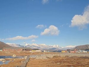
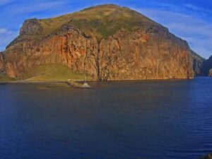
The Qaarsut Airport Webcam looks out from the small Arctic airfield on the Nuussuaq Peninsula in northwest Greenland, the landing strip that serves the island town of Uummannaq. Greenland Airports runs two cameras here. The East camera looks across the gravel apron to snow-dusted tundra, a row of red and blue houses by the shore and, on the horizon, the split, heart-shaped summit of Uummannaq Mountain. The West camera, in the second tab, follows the runway out toward the water, where icebergs drift below a long wall of cliffs. The light changes the scene more than the traffic does. In late October the midday sun climbs only about 8 degrees, so the far cliffs glow gold at noon, while in midsummer the same view sits under a sun that never sets.
Qaarsut Airport, code JQA, opened on 25 September 1999 to give Uummannaq a fixed-wing link. The town sits on a small, steep island across the water, so the airfield was built on the mainland about 25 kilometers (16 miles) to the northwest. Its single gravel runway, 15/33, is 900 meters (2,953 feet) long at an elevation of 88 meters (289 feet), and it was built for the short takeoff and landing aircraft Air Greenland flies here in every season. Before it opened, the 164 kilometer (102 mile) route from Ilulissat to Uummannaq was flown by Sikorsky S-61N helicopters.
Today Air Greenland flies in from Ilulissat, and passengers bound for Uummannaq change to a helicopter for the short hop to Uummannaq Heliport. A 4 kilometer (2.5 mile) gravel road links the airport with Qaarsut itself, a settlement of 172 people in 2025 at the foot of Qilertinnguit, a mountain 1,977 meters (6,486 feet) high that shelters the village from coastal winds. Proposals to close the airport have so far been rejected, with sunk costs, tourism and the revival of mining in 2010 all cited as reasons to keep it.
The shore around it has a long history. Greenland’s first coal mine worked at nearby Qaarsuarsuit from 1778 to 1924, and a few kilometers east of the village lies Qilakitsoq, where eight mummified bodies were found in 1972. They date from around 1475 and are now displayed at the Greenland National Museum in Nuuk.
The Danish Meteorological Institute keeps its station at the airport itself, so the averages describe exactly what the cameras look at. July is the warmest month, with highs around 12 C (54 F) and lows near 6 C (43 F). February and March are the coldest, with highs of about minus 11 C (12 F) and lows near minus 17 C (0 F). Autumn turns fast: September highs still reach about 5 C (41 F), but by October the average high sits just below freezing. By late October a first dusting of snow already lies on the hills and the apron, and through the summer it gives way to bare tundra and open water.
Daylight swings to extremes at almost 71 degrees north. Calculated for the airport’s coordinates, the sun stays below the horizon from about 22 November to 19 January, so in midwinter the picture shows only a band of twilight around midday. The reverse runs from about 14 May to 30 July, when the sun never sets and both cameras show daylight around the clock. The weeks either side of the polar night bring a low gold light that catches the far cliffs around noon, and from February to April the fjord freezes hard enough for dog sleds to cross the sea ice.
Most visitors pass through on the way to Uummannaq, a town of about 1,400 people beneath Uummannaq Mountain, a heart-shaped peak of about 1,170 meters (3,840 feet) that only experienced climbers with technical gear should attempt. Uummannaq Museum, in a former hospital, holds copies of the clothing found with the Qilakitsoq mummies and material from Alfred Wegener’s expedition to the area. Ask there about the historic buildings nearby, including the Whale Blubber House and three turf houses, one of them in use until 1989. Uummannaq Church, built of granite in 1935, stands on the hillside its stone was quarried from.
A short marked trail leads to Santa’s Cabin, a turf hut on the west side of the island built for a Danish television program, and Santa’s office in the yellow Old Doctor’s House answers children’s letters. In winter, dog sled tours run from two hours to several days, and fishermen go out by sled to long-line for halibut through the ice. Summer brings whale watching from July into the autumn and boat trips to Qilakitsoq, where the mummies were found.
These cameras watch other Greenland airfields, including the heliport at the far end of the Qaarsut helicopter link.
It is on the northeastern shore of the Nuussuaq Peninsula in Avannaata municipality, northwest Greenland, about 25 kilometers (16 miles) northwest of Uummannaq and 4 kilometers (2.5 miles) by road from the village of Qaarsut.
The East camera looks over the apron toward low hills, houses by the shore and Uummannaq Mountain. The West camera looks along the runway to the fjord, with icebergs and cliffs on the far side. Air Greenland aircraft and helicopters can appear on flight days.
Air Greenland runs a helicopter from the airport to Uummannaq Heliport. Visit Greenland also lists a boat transfer as an alternative after the flight from Ilulissat.
The gravel runway, 15/33, is 900 meters (2,953 feet) long. The airport sits 88 meters (289 feet) above sea level.
Summers are short and cool, with July highs around 12 C (54 F). Winters are long, and February and March average highs of about minus 11 C (12 F) and lows near minus 17 C (0 F).
No. From about mid-May to the end of July the sun stays above the horizon all night. From late November to mid-January it does not rise at all.
Visit Greenland notes that the northern lights are often visible above Uummannaq, and the season runs from late August to mid-April. Whether the cameras pick them up depends on cloud and the camera’s night exposure.
Between about 22 November and 19 January the sun does not rise at this latitude, so outside a short twilight around midday the picture is dark. That is the polar night, not a camera fault, and daylight returns in late January.
Source: Greenland Airports Live: North
The best new live webcams and site features, once a week.
By subscribing you agree to receive our weekly email. Unsubscribe any time.
 -0.2°C / 31.6°F

 -0.9°C / 30.4°F






 19.4°C / 66.9°F