
 English
 简体中文
 Deutsch
 Français
 Español
 Nederlands
 Svenska
 Italiano
 日本語
 Polski
 Português
 Русский
 Ελληνικά
 العربية
 Türkçe
Live
 12:23:26
 1.3°C / 34.3°F
 Overcast Clouds
 70%
 7 km/h / 4 mph
 07:54
 18:14
Loading forecast…



R Lazy S Ranch, Jackson Hole, Wyoming, USA
2.7°C / 36.9°F
12:23
Attitash Mountain Village, Bartlett, NH, USA
15.2°C / 59.4°F
14:23
Colorado College, East Cache La Poudre Street, Colorado Springs, CO, USA
 16.2°C / 61.2°F
12:23

Westfield, Hampden County, Massachusetts, USA
 16.4°C / 61.5°F
14:23
Lock and Dam 15, Arsenal Island, Illinois, USA
11.1°C / 52°F
13:23

Strawbery Banke Museum, Hancock Street, Portsmouth, NH, USA
 20.9°C / 69.6°F
14:23
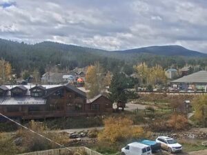
The Togwotee Mountain Lodge Webcam looks across the lodge’s gravel parking lot in the Bridger-Teton National Forest of northwest Wyoming, about 13 kilometers (8 miles) below the top of Togwotee Pass. The long, log-sided lodge and its covered porch fill the left of the frame, a conifer-covered ridge rises behind the lot, and a road bends away on the right. The ground tells you the season. In summer the meadow beyond the lot turns green and a tour van can sit by the fence, while in late October old snow lies in patches and orange tracked snow machines wait beside the rail. A caption across the top of the stream gives the date and local time, so you can see how current the picture is.
Togwotee Mountain Lodge stands on US-26/287 in Teton County, 16.5 miles (27 kilometers) east of Moran Junction on the climb toward the Continental Divide. The drive from Jackson is 48 miles (77 kilometers): 31.5 miles (51 kilometers) north to Moran Junction, then east up the highway. A terrain model puts the lodge at about 2,610 meters (8,570 feet), which is well below the pass itself, so conditions at the summit can differ from what this camera shows.
The property has 28 lodge rooms and 54 cabins, and its dining is the Grizzly Grill and the Red Fox Saloon. It is an Aramark affiliate and a permittee of the Bridger-Teton National Forest, which covers about 1 million hectares (2.5 million acres).
The pass above reaches 2,943 meters (9,655 feet) in the Absaroka Range, with Two Ocean Mountain and Breccia Peak on either side and the Teton Range in view to the west. It takes its name from Togwotee, a subchief under Chief Washakie of the Sheepeater people, a branch of the Shoshone. The name is pronounced TOH-guh-tee.
In a 10-year reanalysis of the lodge’s location, January averages highs near -6°C (21°F) and lows near -14°C (8°F), and December and February sit close to the same numbers. The lodge advertises more than 1,520 centimeters (600 inches) of snow a year, while See Jackson Hole puts a good year at over 1,020 centimeters (400 inches). Both figures are promotional rather than measured records, but either one means the lot on camera can stay white for months. Spring comes late. April highs average only 2°C (36°F) with lows near -8°C (18°F), and snow keeps falling into May.
Summer is short and cool, with July highs near 21°C (69°F) and lows near 7°C (44°F), and afternoon storms can threaten the pass. October averages 6°C (42°F) by day and -5°C (23°F) at night, and old snow already lay in patches around the lot in the late-October frame checked for this post.
Snowmobiling is the main winter draw. About 965 kilometers (600 miles) of groomed trail spread out from this area, part of the Continental Divide Snowmobile Trail System, and the lodge runs guided trips for riders without their own sleds. Dog sled tours are the quieter alternative. In summer the lodge offers side-by-side UTV rentals and horseback riding tours, along with disc golf and games of pool at the Red Fox Saloon.
The national parks are close enough for a day trip. Grand Teton National Park lies about 24 kilometers (15 miles) to the west, with rafting and tubing on the Snake River nearby, and the south entrance of Yellowstone National Park is about 80 kilometers (50 miles) to the north. Turpin Meadow Ranch, about 7 kilometers (4.3 miles) away in a straight line, has its own See Jackson Hole camera. Continue east over Togwotee Pass and the highway leads down to the town of Dubois.
These cameras cover more of the mountain country of northwest Wyoming.
The lodge is in Teton County, northwest Wyoming, on US-26/287 inside the Bridger-Teton National Forest. Its mailing address is Moran, and it sits 16.5 miles (27 kilometers) east of Moran Junction.
The lodge building on the left, its gravel parking lot in the foreground, a forested ridge behind it and a road curving away on the right. Parked vehicles and machines vary, and the snow cover changes through the year.
Long, cold winters and short, cool summers. At the lodge, January highs average near -6°C (21°F) and July highs near 21°C (69°F). The pass is about 330 meters (1,085 feet) higher, so it usually runs colder than the lodge.
The lodge advertises more than 1,520 centimeters (600 inches) a year, and See Jackson Hole says over 1,020 centimeters (400 inches) in a good year. Totals vary widely from winter to winter, and snow can fall from September into May.
The drive is 48 miles (77 kilometers), heading north to Moran Junction and then east on US-26/287.
Only roughly. The Togwotee Mountain Lodge Webcam shows the lot and a short stretch of road at the lodge, and the summit is about 13 kilometers (8 miles) farther up the highway. It is useful for reading snow and visibility at the lodge, not for confirming the road over the pass is open.
It is pronounced TOH-guh-tee. The name comes from a subchief who served under Chief Washakie.
Source: See Jackson Hole
The best new live webcams and site features, once a week.
By subscribing you agree to receive our weekly email. Unsubscribe any time.