
 English
 简体中文
 Deutsch
 Français
 Español
 Nederlands
 Svenska
 Italiano
 日本語
 Polski
 Português
 Русский
 Ελληνικά
 العربية
 Türkçe

Live
R Lazy S Ranch, Teton Village, Wyoming
R Lazy S Ranch, Jackson Hole, Wyoming, USA
 2.7°C / 36.9°F
 12:2312:23:31
 6.3°C / 43.3°F
 Clear Sky
 56%
 07:51
 18:12
Loading forecast…
R Lazy S Ranch, Jackson Hole, Wyoming, USA
2.7°C / 36.9°F
12:23

Grand Targhee Resort, Alta, Wyoming, USA
 8.3°C / 46.9°F
12:23



The White House, Pennsylvania Avenue, Washington, DC, USA
 23.4°C / 74.1°F
14:23




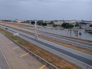

The Dubois Webcam looks across a parking lot and a wide downtown junction in Dubois, Wyoming, a small town on the Wind River in the northwest of the state. A sculpted horse and rider stands in a planted bed behind a log rail fence near the camera, with pickups and SUVs pulled up beside it. Across the road sit a green-roofed building and a row of low storefronts, and a bare ridge closes off the skyline behind them. Most of the interest is in how the same corner changes through the year, from dry pavement and leafless trees in late fall to snow on the lot in winter and the same trees in leaf by summer. US Route 26 runs through town here, so the picture can also serve as a quick look at conditions on the road before a drive over the mountains.
Dubois sits at 2,117 meters (6,946 feet) in Fremont County, with the Wind River running through town and Ramshorn Peak to the north. The 2020 census counted 911 residents. Riverton lies about 113 kilometers (70 miles) east. The camera’s view appears to center on the meeting of Ramshorn Street, which carries US Route 26 through town, and First Street. Range, the telecom cooperative that runs the camera, keeps its Dubois office on South First Street.
The name was a second choice. Residents asked for Tibo, a Shoshone word for “stranger” or “white man,” and the postal service turned it down. Governor Joseph M. Carey then picked Dubois after his friend Fred Dubois, a senator from Idaho. The town says it DOO-boyz, with the accent on the first syllable.
The town’s economy once ran on railroad ties. From 1914 to 1946, crews known as tie hacks, many of them Scandinavian, cut timber in the mountains west of town for the Wyoming Tie and Timber Company. Stacked ties were floated down the Wind River to the railhead at Riverton. The valley is also known for its long tradition of historic dude and guest ranches, and for the Absaroka Mountains that rise nearby.
Winter is cold, and January runs from -11°C to 2°C (13°F to 36°F). Annual snowfall averages about 140 centimeters (55 inches), and the record low is -45°C (-49°F), set on December 5, 1972. Snow can cover the parking lot and the sculpture bed in the foreground during these months, and the ridge on the skyline can turn white as well. Spring is slow to warm up. April ranges from -4°C to 10°C (24°F to 51°F), with nights still below freezing on average, so snow in the frame remains possible.
Summer days are warm and the nights are cool. July runs from 6°C to 26°C (44°F to 79°F), a daily swing of 20°C (36°F). The bare trees around the lot leaf out in this season and can hide part of the street behind them. October cools to a range of -3°C to 13°C (26°F to 56°F). By the end of the month the trees in frame have lost their leaves, and the ridge stands clear behind the rooftops.
Dubois has three museums. The National Bighorn Sheep Center in town covers Rocky Mountain bighorn and wild sheep conservation. The Dubois Museum, at 909 West Ramshorn Street, deals with Native American history, the tie hack industry, guest ranches and local geology, and it has offered trips to area sites with Sheepeater bighorn traps, teepee rings and petroglyphs. The National Museum of Military Vehicles holds more than 500 vehicles and routinely exhibits nearly 350 of them in a 14,864 square meter (160,000 square foot) building.
Wildlife and high country are the other draw. Bighorn sheep winter in Whiskey Basin on Whiskey Mountain, next to the Fitzpatrick Wilderness, and thousands of elk gather on the mountain’s slopes and in the nearby Inberg-Roy Wildlife Habitat Management Area from mid-November through April. West of town, US Route 26 climbs to Togwotee Pass at 2,944 meters (9,658 feet), a Continental Divide crossing in the Absaroka Range named for a Sheepeater subchief who led the Jones Expedition over it in 1873. The Continental Divide Snowmobile Trail passes through the pass area, and hikers can follow sections of the Continental Divide Trail. Northwest of Dubois, the 4.3 meter (14 foot) limestone Tie Hack Historical Monument, built in 1946, marks the logging era.
These cameras cover more of Wyoming, from another small town on the same network to the state’s best-known mountain destinations.
Dubois is in Fremont County in northwest Wyoming, on the Wind River and US Route 26. Riverton is about 113 kilometers (70 miles) to the east, and Togwotee Pass lies to the west on the road toward Jackson Hole.
A parking lot with a horse and rider sculpture in the foreground, then a wide street junction, a green-roofed building, storefronts and a ridge beyond. Traffic crosses the middle of the frame.
Dubois has cold winters and warm summer days with cool nights. January ranges from -11°C to 2°C (13°F to 36°F) and July from 6°C to 26°C (44°F to 79°F), with about 140 centimeters (55 inches) of snow a year.
It is DOO-boyz, with the accent on the first syllable. The town was named after Fred Dubois, a senator from Idaho.
The town sits at 2,117 meters (6,946 feet). Togwotee Pass, on the highway to the west, reaches 2,944 meters (9,658 feet).
Whiskey Basin on Whiskey Mountain, near town, is the wintering ground for the herd. The National Bighorn Sheep Center in Dubois explains the animals and their conservation.
Range says all of its webcams stream free 24 hours a day, every day of the year, so there is no daily off-air period to wait out.
Source: Range
The best new live webcams and site features, once a week.
By subscribing you agree to receive our weekly email. Unsubscribe any time.
 18.7°C / 65.7°F
 23.2°C / 73.8°F