Live

 19:02:18
 12.1°C / 53.8°F
 Clear Sky
 62%
62% 6 km/h / 4 mph
 07:28
07:28 18:12
18:12Loading forecast…
The Kingston Webcam looks out over Confederation Basin, the downtown marina that sits directly in front of Kingston City Hall on the north shore of Lake Ontario. A round stone tower stands on its own point at the mouth of the basin, and past it the harbour opens toward Fort Henry on the far shore. Rows of docked sailboats and cruisers fill the middle of the frame from spring through fall, with the lawns and fountain of Confederation Park in the foreground and traffic moving along the waterfront road below. The City of Kingston runs five more cameras on the same page, reaching the market square, two stretches of lake shoreline, the Olympic sailing harbour and the city’s newest bridge.
Kingston stands where Lake Ontario narrows and becomes the St. Lawrence River, at the western edge of the Thousand Islands and 93 meters (305 feet) above sea level. The 2021 census counted 132,485 residents. Incorporated in 1846, the city had already had its most consequential years: from 1841 to 1844 it was the first capital of the Province of Canada, and that parliament first sat on June 13, 1841, on the ground now occupied by Kingston General Hospital.
The nickname that stuck came out of a disaster. A dock fire on April 18, 1840 spread through the downtown, and the rebuilding that followed was done in limestone and brick rather than wood, a period local histories call the Limestone Revolution. City Hall is the clearest survivor of it: begun in 1843 and finished in 1844, built of limestone in the shape of a T, with a market building running west toward King Street. It faces Springer Market Square, where a public market has operated continuously since 1801. The square was rebuilt in 2008 and renamed to recognize a one million dollar gift from the Springer family.
The water in the main shot is a working marina rather than scenery. Confederation Basin has 350 finger dock slips and takes power boats and sailboats up to 30 meters (100 feet), which is why the frame fills and empties with the season. Two institutions shape the rest of the city: Queen’s University, founded in 1842 and now teaching more than 28,000 students, and the Royal Military College of Canada, founded in 1876 with roughly 1,000 cadets. Fort Henry, raised in the War of 1812 period to guard the gateway to the Great Lakes, still looks down on the harbour from the opposite side.
Winter is long and the marina empties for it. January averages a daily high of minus 2.6 C (27.3 F) and a low of minus 11.5 C (11.3 F), and the city collects about 159.9 centimeters (63.0 inches) of snow across a normal year. Through those months the docks are pulled and the park below the camera is white more often than green. April brings a high near 10.0 C (50.0 F) and a low of 0.9 C (33.6 F), and the picture changes quickly once the docks go back in.
July is the peak of it, with an average high of 25.4 C (77.7 F) and an overnight low of 16.1 C (61.0 F). That is when the slips are full, the fountain runs, and the lake beyond the tower carries sails most afternoons. October cools to a high of 13.8 C (56.8 F) and a low of 5.1 C (41.2 F), the sun sits lower and throws long shadows across the park, and boats leave the basin week by week. Weather coming off the lake can flatten the picture at any time of year, so a gray frame on the Kingston Webcam is normal rather than a fault with the camera.
Almost everything in the main frame can be reached on foot. Springer Market Square holds the public market in front of City Hall, and Confederation Basin sells transient slips, so a boat arriving off the St. Lawrence can tie up in the middle of downtown. Across the harbour, Fort Henry occupies the high ground as a national historic site, and the Great Lakes Museum covers the shipbuilding and navigation history of the inland seas. East of the city the Thousand Islands begin, and the Cataraqui River behind the downtown is the southern end of the Rideau Canal, a UNESCO World Heritage Site.
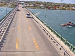
The other cameras on the Kingston Webcam page point at places worth the walk or the short drive. Portsmouth Olympic Harbour, west of downtown, was redeveloped for the sailing events of the 1976 Summer Olympics in Montreal and still hosts the CORK regatta each summer. Breakwater Park and Richardson Beach put swimming and open shoreline within a few minutes of the university. The Waaban Crossing, opened on December 13, 2022, runs 1.2 kilometers (0.75 miles) over the Cataraqui River to link the east and west sides of the city; its Ojibwe name refers to the dawn and the morning light in the east.
If this stretch of Ontario shoreline is your thing, these three are the natural next stop.
Kingston is in eastern Ontario, Canada, at the point where Lake Ontario drains into the St. Lawrence River. It sits between the Prince Edward County and Thousand Islands regions.
The main camera covers Confederation Basin, the downtown marina in front of City Hall, with the stone tower at the mouth of the basin, open Lake Ontario beyond it and Confederation Park in the foreground. Five further cameras reach Springer Market Square, Breakwater Park, Richardson Beach, Portsmouth Olympic Harbour and the Waaban Crossing.
Cold winters and warm summers. January averages minus 2.6 C (27.3 F) by day and minus 11.5 C (11.3 F) at night, with about 159.9 centimeters (63.0 inches) of snow a year, while July averages 25.4 C (77.7 F) by day and 16.1 C (61.0 F) overnight.
A dock fire on April 18, 1840 burned through the downtown. The city rebuilt in local limestone and brick instead of wood, and enough of that stonework survives, City Hall included, that the nickname stuck.
Yes. Kingston was the first capital of the Province of Canada from 1841 to 1844. The first sitting of its parliament took place on June 13, 1841, on the site now occupied by Kingston General Hospital.
It is the open square in front of City Hall, home to a public market that has run without a break since 1801. The square was rebuilt in 2008 and renamed after the Springer family donated one million dollars toward the work.
The bridge opened on December 13, 2022. It carries traffic 1.2 kilometers (0.75 miles) across the Cataraqui River between the east and west sides of Kingston, and its name comes from an Ojibwe word for the dawn.
Source: City of Kingston
The best new live webcams and site features, once a week.
By subscribing you agree to receive our weekly email. Unsubscribe any time.




 14.5°C / 58.1°F