Live

 19:42:39
 -3.1°C / 26.4°F
 Broken Clouds
 93%
 10 km/h / 6 mph
 08:32
 17:35
Loading forecast…
The Langjokull Base Camp Webcam watches Geldingafell, the highland camp that Mountaineers of Iceland runs on the east side of Langjokull, the second-largest ice cap in Iceland. Three timber huts with white metal roofs fill the middle of the frame, with a cube-shaped tank beside the long hut and one of the company’s big off-road trucks sometimes parked at the end of the row. Behind them a broad slope climbs to a rounded skyline. The camp stands about 625 meters (2,050 feet) above sea level, and by late October the roofs and the slope were already white. A second camera, the South View tab, looks the other way across an open snowfield to the horizon. The date and time in the top-left corner come from the camera itself, so a clock that stops moving means the picture has frozen.
Geldingafell sits beside Skalpanesvegur, road 336, a gravel road that leaves the Kjolur highland route and runs west toward the ice. It ends about 5.5 kilometers (3.4 miles) farther on at Skalpanes. The nearest edge of Langjokull, the outlet glacier Sudurjokull, lies roughly 7 kilometers (4.3 miles) north-northwest of the huts, and the smaller Blafellsjokull glacier begins about 3 kilometers (1.9 miles) to the east-southeast. The lake Hvitarvatn is about 6 kilometers (3.7 miles) away, Gullfoss is 24 kilometers (15 miles) away in a straight line, and Reykjavik about 106 kilometers (66 miles).
Langjokull covers about 870 square kilometers (340 square miles). It runs roughly 50 kilometers (31 miles) from end to end and 15 to 20 kilometers (9.3 to 12.4 miles) across, the ice is up to 580 meters (1,900 feet) thick, and its highest point, Baldjokull at the northern end, reaches about 1,450 meters (4,760 feet). Few rivers flow straight off it, because much of the meltwater travels underground. About two-thirds of the water in Hvitarvatn appears to reach the lake from the ice through underwater channels, and two outlet glaciers, Nordurjokull and Sudurjokull, ran into the lake until about 1900 before pulling back.
Mountaineers of Iceland was founded in 1996 and runs snowmobile, super jeep and glacier super truck tours, mostly on Langjokull, from base camps on both the east and west sides of the ice cap. Geldingafell is the eastern one. Trips on the company’s list include a Gullfoss snowmobile tour and an Ice Cave and Snowmobiling outing, and its webcam page shows temperature, pressure and humidity readings beside the stream.
Reanalysis data for this spot, averaged over 2015 to 2024, describes a long, cold winter. From December to February daytime highs sit around -3 C (27 F) and nights fall to about -8 or -9 C (16 to 18 F), and March is barely milder. Highs do not climb above freezing until April, when they reach about 0 C (32 F). Light is the bigger limit for the camera in winter. At the December solstice the camp gets just under 4 hours of daylight, and the midday sun clears the horizon by only about 2 degrees, so even the brightest frames show low light and long shadows on the snow.
Summer is short and cool. May highs average about 4 C (39 F), and July, the warmest month, reaches about 11 C (52 F) by day and 5 C (41 F) at night. Around the June solstice the sun is up for more than 21 hours, so the huts stay lit almost around the clock, although the camp lies south of the Arctic Circle and never gets a true midnight sun. Autumn closes in fast. September highs average about 6 C (43 F), October about 2 C (36 F) with nights below freezing, and by November the average high is under 0 C (32 F).
The camp exists for trips onto the ice, and the operator’s snowmobile and ice cave tours are the main reason to come up here. The nearest big sight is Gullfoss, where the Hvita river drops 11 meters (36 feet) and then 21 meters (69 feet) into a crevice 32 meters (105 feet) deep and about 2.5 kilometers (1.6 miles) long. Average flow is about 141 cubic meters (5,000 cubic feet) per second in summer and 80 cubic meters (2,800 cubic feet) in winter. The falls became a permanent conservation site in 1979, and a stone memorial above them carries the profile of Sigridur Tomasdottir, who is credited with saving them from foreign investors. The Geysir hot spring area lies about 30 kilometers (19 miles) from the camp.
North of the junction, the Kjolur road crosses a plateau of about 600 to 700 meters (1,970 to 2,300 feet) between Langjokull and Hofsjokull. Toward its northern end, the Hveravellir hot springs still have one spot used for bathing, and in the 18th century the outlaw Fjalla-Eyvindur made his home there. The volcanic Kerlingarfjoll range rises northeast of the road. The area appears in the Icelandic sagas, and the Old Kjalvegur, a summer shortcut along Langjokull, is still used for trekking and horse riding.
More snow, ice and Icelandic mountain views on the site:
The Geldingafell base camp is on road 336, on the east side of Langjokull in Iceland’s southern highlands. It is about 24 kilometers (15 miles) from Gullfoss in a straight line and roughly 106 kilometers (66 miles) from Reykjavik.
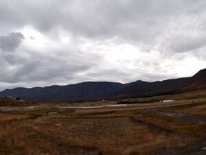
The main camera shows the camp’s three huts, the snow-covered slope behind them and, at times, a large tour truck. The South View tab looks across an open snowfield to the horizon. The ice cap itself, about 7 kilometers (4.3 miles) away, is not in either frame.
Cold for most of the year. Winter highs average about -3 C (27 F) with nights near -8 C (18 F), while July highs reach only about 11 C (52 F).
It covers about 870 square kilometers (340 square miles), which makes it the second-largest ice cap in Iceland after Vatnajokull, and its ice is up to 580 meters (1,900 feet) thick.
Yes. The ice cap is retreating, its largest recorded extent dates from 1840, and some researchers think it could disappear in about 150 years if warming continues at its recent pace.
Just under 4 hours at the December solstice, with the sun only about 2 degrees above the horizon at midday. By late June the camp gets more than 21 hours of daylight.
Mountaineers of Iceland, a tour company founded in 1996 that runs snowmobile, super jeep and super truck tours on Langjokull from base camps on the east and west sides of the ice.
Source: Mountaineers of Iceland
The best new live webcams and site features, once a week.
By subscribing you agree to receive our weekly email. Unsubscribe any time.
 0.8°C / 33.4°F

 0.4°C / 32.7°F
 -3.3°C / 26.1°F
 1.2°C / 34.2°F

 -2.2°C / 28°F