Live

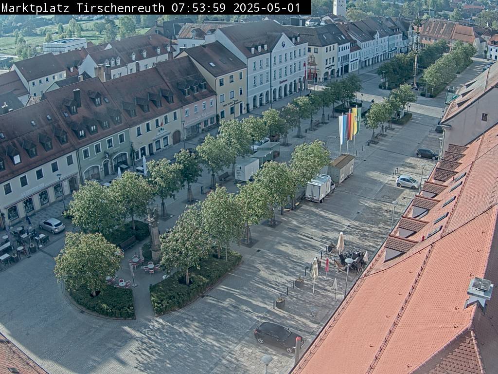
Stream hours: This is a still camera: the town replaces the picture about once a minute, and the player reloads it on its own.
 13:26:04
 12.6°C / 54.7°F
 Broken Clouds
 83%
83% 6 km/h / 4 mph
 07:31
07:31 18:20
18:20Loading forecast…
The Tirschenreuth Webcam looks down the length of Maximilianplatz, the long market square at the heart of this small town in northeast Bavaria, from high above its northern end. Gabled townhouses with steep tiled roofs and rows of dormer windows line the left side of the frame, cars park along the right, and the 18th-century Trinity Column rises from a planted island in the foreground, with cafe tables set out around it. Rows of young trees run down the middle of the square and mark the seasons, bare in winter and in leaf through the summer. On Thursday mornings the white trailers of the weekly market pull up between them.
Tirschenreuth sits in the north of the Upper Palatinate, about 15 kilometers (9 miles) from the Czech border, at an elevation of 504 meters (1,654 feet). The town had 8,467 residents at the end of 2025 and gives its name to the surrounding district. A settlement here is first recorded in 1130, and the market square was laid out in the 14th century as part of a planned expansion of the town.
Maximilianplatz is unusually wide for a small town: 235 meters (771 feet) long and 47 meters (154 feet) across. It is named after King Maximilian II of Bavaria, who died in 1864, and it was rebuilt between 2007 and 2009 with care for its historic layout. The square runs from the parish church of Maria Himmelfahrt, which probably dates from the second half of the 13th century, to the Klettnersturm at the southern end, a tower that closed off the old town and survives from the former town wall.
The great fire of 30 July 1814 destroyed nearly the whole town within a few hours. The town hall, a three-story Renaissance building of 1582 and 1583, lost everything except its facade on the square and the Renaissance oriel window decorated with coats of arms. The Trinity Column in the foreground is a plague column from the 18th century. It had been moved to the Mount of Olives grotto beside the parish church and came back to its old place on the square in 2008, during the renovation. Farther along stand a monument to Johann Andreas Schmeller, the linguist and dialect researcher who is the town’s most famous son, and two fountains: the Cloth Makers’ Fountain, for a trade that survives in the oldest working cloth mill in Germany, and the Carp Fountain in front of the town hall.
Tirschenreuth has a cool inland climate. Ten years of weather data for the town, from 2015 to 2024, give average January highs of about 2 C (36 F) and lows of minus 3 C (27 F), and nights stay below freezing on average from December through February. Winter is when the Tirschenreuth Webcam can show snow on the roofs, and around the December solstice the town gets only about eight hours of daylight.
Spring warms quickly, from highs near 8 C (46 F) in March to 17 C (62 F) in May, and the trees along the square come into leaf. July and August average highs of about 23 C (73 F) with lows of 13 to 14 C (55 to 57 F), and with more than 16 hours of daylight in late June the light stays on the square well into the evening. September still reaches about 18 C (64 F) and October about 13 C (55 F), when the leaves on the square turn yellow before nights drop close to freezing again in November.
The MuseumsQuartier, about 150 meters (490 feet) from the square, covers centuries of local fishing on three floors, with large aquariums of carp, sturgeon and other native fish, plus collections of Tirschenreuth porcelain, nativity carving and icons. Next to it lies the Fischhofpark, built around the Fischhof, once the tithe barn and summer residence of the abbots of Waldsassen. Its town pond of about 6 hectares (15 acres) was partly reflooded for the 2013 regional garden show, so the old stone Fischhof Bridge, which had stood on dry ground since the monastery was dissolved, crosses water again. Beside it runs the Max Gleissner Bridge, a timber stress-ribbon bridge that the town describes as the longest of its kind in Europe. Back near the square, the carillon of the Fatima Church plays several times a day from a repertoire of 94 melodies.
Around the town lies the Tirschenreuth Teichpfanne, one of the largest and oldest pond landscapes in Germany, inside the Waldnaabaue nature project, which covers about 3,000 hectares (7,400 acres) along the Waldnaab River. The Himmelsleiter, a wood and metal viewing tower beside the Vizinalbahn cycle path on the line of an old local railway, climbs 100 steps to a platform above the ponds. Farther afield, the basilica and abbey of Waldsassen are 20 kilometers (12 miles) away, the castle at Falkenberg and the Waldnaab valley 11 kilometers (7 miles), and the Czech spa town of Marianske Lazne (Marienbad) about 45 kilometers (28 miles).
More old town squares in Germany, and a stork nest elsewhere in the Upper Palatinate:
Tirschenreuth is in the north of the Upper Palatinate, in northeast Bavaria, Germany. The nearest larger town is Weiden, about 30 kilometers (19 miles) to the south.
The camera looks along Maximilianplatz, the town’s market square, from above its northern end. The Trinity Column on its planted island is in the foreground, with gabled townhouses on the left, parking on the right and rows of trees leading toward the far end of the square.
Winters are cold, with January highs of about 2 C (36 F) and lows of minus 3 C (27 F). Summers are mild, with July and August highs around 23 C (73 F).
A weekly market runs every Thursday morning, with direct sellers from the region setting up on the square. On the camera it shows as a cluster of white sales trailers between the trees.
It is the Trinity Column, an 18th-century plague column that returned to its historic spot on Maximilianplatz during the 2008 renovation of the square.
The town lies in the Tirschenreuth Teichpfanne, one of the largest and oldest pond landscapes in Germany, where more than 3,700 ponds and waters are said to have existed at one time. Pond fish farming is still one of the town’s important trades, which is why a carp fountain stands in front of the town hall.
About 15 kilometers (9 miles). The historic town of Cheb is about 30 kilometers (19 miles) away, Marianske Lazne about 45 kilometers (28 miles) and Karlovy Vary about 75 kilometers (47 miles).
Source: Stadt Tirschenreuth
The best new live webcams and site features, once a week.
By subscribing you agree to receive our weekly email. Unsubscribe any time.
 18.7°C / 65.7°F




 17.8°C / 64°F