
Live

 13:30:25
 11°C / 51.8°F
 Broken Clouds
 76%
76% 5 km/h / 3 mph
 07:14
07:14 18:03
18:03Loading forecast…
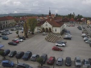
The Miedzylesie Webcam looks down on Plac Wolnosci, the main square of a small town in Poland’s Klodzko Land, a few kilometers from the Czech border. From a high vantage point beside the castle, the camera takes in the lawns, paths and round fountain at the heart of the square, a column monument on a stepped base, and the rows of red-roofed townhouses that line its far side. The long green roofs of the castle fill the lower right corner, with a tower at the edge of the frame, and a ridge of wooded hills closes the horizon. It is a quiet view that moves with the light and the seasons. Cars come and go from the parking area on the left, the trees on the square turn yellow in October, and the hills can fade behind low cloud.
Miedzylesie, known in German as Mittelwalde, sits on the Nysa Klodzka river at the southern end of the Upper Nysa valley, which runs north toward Klodzko. The town lies at 435 to 470 meters (1,427 to 1,542 feet) above sea level, between the Bystrzyckie Mountains to the west and the Snieznik Massif to the east. It is small, with 2,575 residents in 2019 and an area of 14.37 square kilometers (5.55 square miles). The village of Boboszow, on the way to the Czech border, is about 5 kilometers (3 miles) to the south-southeast.
The town had its charter before 1290, and a document issued in Prague in 1294 records King Wenceslaus II of Bohemia handing the area to the Cistercians. Hussite armies destroyed Miedzylesie completely in 1428, and Swedish troops burned it again during the Thirty Years’ War. The road between Wroclaw and Vienna was built through the valley in 1827 to 1833, and the railway toward Prague and Vienna followed in 1875.
The castle beside the square is a Baroque castle and palace complex and the most valuable monument in town. Its oldest part, the Black Tower, is the only piece left of a Gothic castle from around 1370 that was wrecked during the Hussite wars. Next to it stands the Corpus Christi parish church, whose pulpit, made in 1760, takes the shape of a boat with a mast and sail. In 1683 the church received a painting of the Madonna that Pope Innocent XI had given to King John III Sobieski of Poland after his victory at Vienna.
Miedzylesie has cold winters and warm, fairly wet summers. Averages for 2015 to 2024 put January highs at about 1 C (34 F) and lows around -4 C (25 F), and average overnight lows stay below freezing from December through March. Snow can settle on the red roofs and the lawns of the square in winter, and with the town at about 50 degrees north, late December brings only around 8 hours of daylight. Spring warms quickly: April averages 12 C (54 F) by day but still drops to about 3 C (37 F) at night, and March and April are the driest months, with roughly 61 to 63 millimeters (2.4 to 2.5 inches) of rain each.
Summer is the warmest and wettest season. July and August highs average about 23 C (73 F), with nights around 14 C (57 F), and August is the wettest month at about 105 millimeters (4.1 inches). Late June gives more than 16 hours of daylight, so the square stays lit well into the evening. October, when the trees around the fountain turn yellow, averages 13 C (55 F) by day and 6 C (43 F) at night, and by November highs are down to about 6 C (43 F).
The town is a gateway to the Snieznik Massif to the east. Its summit, Snieznik, reaches 1,423 meters (4,669 feet) on the Polish and Czech border, about 14 kilometers (9 miles) northeast of the square in a straight line. The Miedzylesie commune lies in the buffer zone of the Snieznik Landscape Park, with ground ranging from 368 to 1,326 meters (1,207 to 4,350 feet). About 11 kilometers (7 miles) to the northeast, near the village of Miedzygorze, Wilczki Falls drops 22 meters (72 feet) on the Wilczka river at 570 meters (1,870 feet) above sea level. It is the second highest waterfall in the Polish part of the Sudetes, after Kamienczyk Falls.
Further northeast, the Bear Cave near Kletno lies about 19 kilometers (12 miles) from Miedzylesie. Its first 200 meters (660 feet) of passages were found in October 1966, when a newly opened quarry broke into them, and deeper halls followed in 1967 and 1972. About 33 kilometers (20 miles) north, Klodzko is home to Klodzko Fortress, a complex of modern era fortifications with an auxiliary fort on Owcza Gora. Back in Miedzylesie itself, the castle and the Corpus Christi church with its boat pulpit stand right beside the square the camera watches.
More small towns, castles and squares in this corner of Central Europe:
Miedzylesie is in Klodzko County, in the Lower Silesian Voivodeship of southwest Poland. It sits on the Nysa Klodzka river close to the Czech border, about 33 kilometers (20 miles) south of Klodzko.
The camera looks over Plac Wolnosci from above: the lawns, fountain and column monument in the middle of the square, the red-roofed townhouses around it, the green roofs and a tower of the castle on the right, and wooded hills on the horizon.
Winters are cold, with January averaging about 1 C (34 F) by day and -4 C (25 F) at night. Summers are mild to warm, with July and August highs near 23 C (73 F), and August is usually the wettest month.
Very close. The village of Boboszow, on the way to the border, is about 5 kilometers (3 miles) south-southeast of the square, and the road and railway through the valley continue into the Czech Republic.
Yes. A Baroque castle and palace complex stands beside the main square, and its Black Tower survives from a Gothic castle of around 1370. Its green roofs are in the right of the camera’s frame.
The town lies at 435 to 470 meters (1,427 to 1,542 feet) above sea level, in the valley between the Bystrzyckie Mountains and the Snieznik Massif.
The summit of Snieznik, 1,423 meters (4,669 feet) high, is about 14 kilometers (9 miles) northeast of Miedzylesie in a straight line. Trails and roads to it are longer than that.
The camera is operated by AirMAX, a Polish telecommunications company that streams it on its own website and describes the broadcast as running 24/7.
Source: AirMAX
The best new live webcams and site features, once a week.
By subscribing you agree to receive our weekly email. Unsubscribe any time.

 10.1°C / 50.2°F




 11.5°C / 52.7°F